IMAGES TAKEN NEAR TO
Foster Street, HARLOW, CM17 9HP
Introduction
This page details the photographs taken nearby to Foster Street, CM17 9HP by members of the Geograph project.
The Geograph project started in 2005 with the aim of publishing, organising and preserving representative images for every square kilometre of Great Britain, Ireland and the Isle of Man.

There are currently over 7.5m images from over14,400 individuals and you can help contribute to the project by visiting https://www.geograph.org.uk
Image Map (Loading...)


Getting Data...Please wait
Leaflet Map data © OpenStreetMap
Images are licensed for reuse under creativecommons.org/licenses/by-sa/2.0
Notes
- Clicking on the map will re-center to the selected point.
- The higher the marker number, the further away the image location is from the centre of the postcode.
Image Listing (6 Images Found)
Images are licensed for reuse under creativecommons.org/licenses/by-sa/2.0
Image
Details
Distance
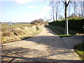
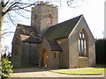
3
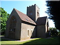
Former All Saints' Church, Foster Street
C19 church now converted to residential use.
Image: © Bikeboy
Taken: 21 Jun 2014
0.17 miles
4
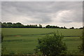
Footpath from Foster Street to Shoe Lane
The water tower in the distance is a well-known feature for anyone travelling along the M11. It is on the west side, just north of the Harlow turn off.
Image: © Marathon
Taken: 27 Jun 2015
0.21 miles
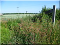
6
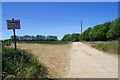
Bridleway to Burrs Farm
This is Bridleway 191_61 it is 363m long.
Image: © Glyn Baker
Taken: 29 May 2020
0.21 miles