IMAGES TAKEN NEAR TO
Carters Mead, HARLOW, CM17 9EZ
Introduction
This page details the photographs taken nearby to Carters Mead, CM17 9EZ by members of the Geograph project.
The Geograph project started in 2005 with the aim of publishing, organising and preserving representative images for every square kilometre of Great Britain, Ireland and the Isle of Man.

There are currently over 7.5m images from over14,400 individuals and you can help contribute to the project by visiting https://www.geograph.org.uk
Image Map (5 Images)


Getting Data...Please wait
Leaflet Map data © OpenStreetMap
Images are licensed for reuse under creativecommons.org/licenses/by-sa/2.0
Notes
- Clicking on the map will re-center to the selected point.
- The higher the marker number, the further away the image location is from the centre of the postcode.
Image Listing (5 Images Found)
Images are licensed for reuse under creativecommons.org/licenses/by-sa/2.0
Image
Details
Distance
4
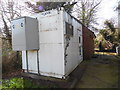
Church Langley Telephone Exchange, Essex
Situated in Old London Road CM17 9HN, it has the code EACHU and supplies telephone and broadband services to 1,477 residential and 11 non-residential premises in the Church Langley area. This TE would appear to comprise the white container and the red brick building behind it.
Image: © David Hillas
Taken: 5 Apr 2018
0.22 miles
5
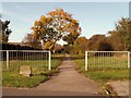
Public bridleway to Kingsdon Lane from Red Lion Lane
Image: © Robert Edwards
Taken: 24 Oct 2008
0.24 miles