IMAGES TAKEN NEAR TO
New Way Lane, HARLOW, CM17 0NT
Introduction
This page details the photographs taken nearby to New Way Lane, CM17 0NT by members of the Geograph project.
The Geograph project started in 2005 with the aim of publishing, organising and preserving representative images for every square kilometre of Great Britain, Ireland and the Isle of Man.

There are currently over 7.5m images from over14,400 individuals and you can help contribute to the project by visiting https://www.geograph.org.uk
Image Map
Images are licensed for reuse under creativecommons.org/licenses/by-sa/2.0
Notes
- Clicking on the map will re-center to the selected point.
- The higher the marker number, the further away the image location is from the centre of the postcode.
Image Listing (5 Images Found)
Images are licensed for reuse under creativecommons.org/licenses/by-sa/2.0
Image
Details
Distance
1
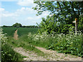
Footpath north-west from New Way Lane
Footpath 198_53 heads towards Harlow Tye.
Image: © Robin Webster
Taken: 5 Jun 2013
0.13 miles
2
Footpath east from New Way Lane
Footpath 192_31 heads indirectly to several places via other paths, but to nowhere in particular itself.
Image: © Robin Webster
Taken: 5 Jun 2013
0.15 miles
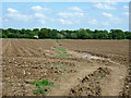
3
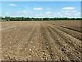
Furrowed field
Is this for potatoes? The somewhat grassy trace going skew across the furrows is a public footpath.
Image: © Robin Webster
Taken: 5 Jun 2013
0.19 miles
4
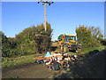
'Fly-tipping', High Laver, Essex
Whilst this farmer was working in fields off New Way Lane, someone dumped rubbish across the entrance!
Image: © John Winfield
Taken: 17 Nov 2005
0.21 miles
5
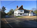
The John Barleycorn Public House, Threshers Bush, Essex
Image: © John Winfield
Taken: 17 Nov 2005
0.22 miles