IMAGES TAKEN NEAR TO
Threshers Bush, HARLOW, CM17 0NS
Introduction
This page details the photographs taken nearby to CM17 0NS by members of the Geograph project.
The Geograph project started in 2005 with the aim of publishing, organising and preserving representative images for every square kilometre of Great Britain, Ireland and the Isle of Man.

There are currently over 7.5m images from over14,400 individuals and you can help contribute to the project by visiting https://www.geograph.org.uk
Image Map
Images are licensed for reuse under creativecommons.org/licenses/by-sa/2.0
Notes
- Clicking on the map will re-center to the selected point.
- The higher the marker number, the further away the image location is from the centre of the postcode.
Image Listing (17 Images Found)
Images are licensed for reuse under creativecommons.org/licenses/by-sa/2.0
Image
Details
Distance
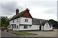
1
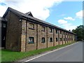
Bush Hal Farm Malthouse, Threshers Bush
Built in 1847. Now converted to residential use. See http://www.britishlistedbuildings.co.uk/en-473134-bush-hall-farm-malthouse-high-laver-esse#.VesIeBHBzGc for entry in British Listed Buildings.
Image: © Bikeboy
Taken: 28 Aug 2015
0.04 miles
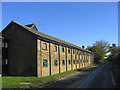
2

Malthouse Sale
I assume it is only one of the dwellings in this converted Victorian Malthouse that is for sale see https://britishlistedbuildings.co.uk/101067134-bush-hall-farm-malthouse-high-laver#.XtJfTTpKicl for more info.
Image: © Glyn Baker
Taken: 29 May 2020
0.05 miles
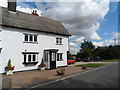
4
Bush Hall Farm, Threshers Bush, Essex
Image: © John Winfield
Taken: 17 Nov 2005
0.08 miles
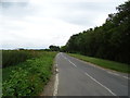
5
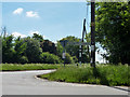
Road junction, Threshers Bush
A four-way junction, or staggered crossroads.
Image: © Robin Webster
Taken: 5 Jun 2013
0.08 miles
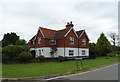
6
John Barleycorn
I am beginning to feel thirsty with all the pubs bing shut for two months already. How many will survive the lockdown?
Image: © Glyn Baker
Taken: 29 May 2020
0.09 miles
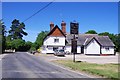
8
The John Barleycorn pub, Threshers Bush
Originally a C15 house, extended in the C19 and C20. See http://www.britishlistedbuildings.co.uk/en-118104-john-barleycorn-public-house-high-laver-#.VesIgRHBzGc for entry in British Listed Buildings.
Image: © Bikeboy
Taken: 28 Aug 2015
0.09 miles
10
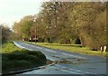
Part of Threshers Bush
The road here is called Threshers Bush and this is looking in the direction of Harlow.
Image: © Robert Edwards
Taken: 14 Apr 2008
0.09 miles