IMAGES TAKEN NEAR TO
Moor Hall Road, HARLOW, CM17 0LP
Introduction
This page details the photographs taken nearby to Moor Hall Road, CM17 0LP by members of the Geograph project.
The Geograph project started in 2005 with the aim of publishing, organising and preserving representative images for every square kilometre of Great Britain, Ireland and the Isle of Man.

There are currently over 7.5m images from over14,400 individuals and you can help contribute to the project by visiting https://www.geograph.org.uk
Image Map
Images are licensed for reuse under creativecommons.org/licenses/by-sa/2.0
Notes
- Clicking on the map will re-center to the selected point.
- The higher the marker number, the further away the image location is from the centre of the postcode.
Image Listing (6 Images Found)
Images are licensed for reuse under creativecommons.org/licenses/by-sa/2.0
Image
Details
Distance
1
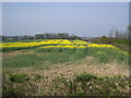
Crop Field
Oil seed rape growing next to the M11 motorway, running along the right of the fence.
Image: © Lynda Poulter
Taken: 14 Apr 2007
0.20 miles
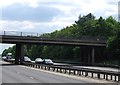
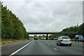
2

Matching Rd Crosses the M11
As a bonus some Image
Image: © Glyn Baker
Taken: 29 May 2020
0.23 miles
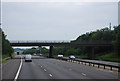
3
M11 From Matching Road / Moor Hall Road Flyover
Looking Cambridge-bound; see also Image
Image: © Glyn Baker
Taken: 29 May 2020
0.24 miles
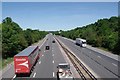
4
Matching Road crosses the M11
The Matching Road bridge matches many other road bridges over the M11.
Image: © Robin Webster
Taken: 7 Oct 2011
0.25 miles