IMAGES TAKEN NEAR TO
Guilfords, HARLOW, CM17 0HU
Introduction
This page details the photographs taken nearby to Guilfords, CM17 0HU by members of the Geograph project.
The Geograph project started in 2005 with the aim of publishing, organising and preserving representative images for every square kilometre of Great Britain, Ireland and the Isle of Man.

There are currently over 7.5m images from over14,400 individuals and you can help contribute to the project by visiting https://www.geograph.org.uk
Image Map (Loading...)


Getting Data...Please wait
Leaflet Map data © OpenStreetMap
Images are licensed for reuse under creativecommons.org/licenses/by-sa/2.0
Notes
- Clicking on the map will re-center to the selected point.
- The higher the marker number, the further away the image location is from the centre of the postcode.
Image Listing (3 Images Found)
Images are licensed for reuse under creativecommons.org/licenses/by-sa/2.0
Image
Details
Distance
1
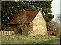
Norman Chapel, Harlowbury, Essex
This small chapel consists of a Norman nave and chancel in one. It lies to the far east of Harlow New Town.
Image: © Robert Edwards
Taken: 7 Apr 2006
0.12 miles
2
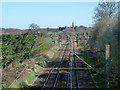
Railway towards Bishop's Stortford and Cambridge
Looking from the Old Road bridge, Harlow.
Image: © Robin Webster
Taken: 16 Mar 2014
0.23 miles
3
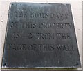
Old Boundary Marker off Bury Road, Harlow parish
Estate Boundary Marker - MOD by the UC road, in parish of Harlow (Harlow District), Bury Road, to rear of No 75 on wall of former drill hall.
Inscription reads:-
THE BOUNDARY
OF THIS PROPERTY
IS 42" FROM THE
FACE OF THIS WALL
Surveyed
Milestone Society National ID: EX_MODHARL01em
Image: © Milestone Society
Taken: Unknown
0.24 miles