IMAGES TAKEN NEAR TO
Old Oak Way, HARLOW, CM17 0GD
Introduction
This page details the photographs taken nearby to Old Oak Way, CM17 0GD by members of the Geograph project.
The Geograph project started in 2005 with the aim of publishing, organising and preserving representative images for every square kilometre of Great Britain, Ireland and the Isle of Man.

There are currently over 7.5m images from over14,400 individuals and you can help contribute to the project by visiting https://www.geograph.org.uk
Image Map (Loading...)


Getting Data...Please wait
Leaflet Map data © OpenStreetMap
Images are licensed for reuse under creativecommons.org/licenses/by-sa/2.0
Notes
- Clicking on the map will re-center to the selected point.
- The higher the marker number, the further away the image location is from the centre of the postcode.
Image Listing (7 Images Found)
Images are licensed for reuse under creativecommons.org/licenses/by-sa/2.0
Image
Details
Distance
1
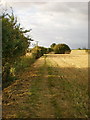
Footpath
From the B183 to the River Stort
Image: © Alexander P Kapp
Taken: 14 Sep 2009
0.16 miles
2

Arable land north of Churchgate Street
Image: © Alexander P Kapp
Taken: 14 Sep 2009
0.16 miles

4
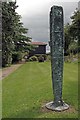
Sculpture in The Gibberd Garden
The Gibberd Garden is famous for its numerous works of art. http://www.thegibberdgarden.co.uk/info.php
I was lucky the threatening sky never delivered.
Image: © Glyn Baker
Taken: 16 Jun 2016
0.24 miles
5
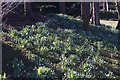
View of snowdrops in the Gibberd Garden #4
Looking south-southwest.
Image: © Robert Lamb
Taken: 25 Feb 2018
0.24 miles
6

View of snowdrops in the Gibberd Garden #5
Looking south-southwest.
Image: © Robert Lamb
Taken: 25 Feb 2018
0.25 miles
7
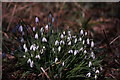
View of snowdrops in the Gibberd Garden #4
Taken when the Gibberd Garden is open to the public for the three Sundays in February only - one of three events called Snowdrop Sundays. The Gibberd Garden is absolutely swarming with snowdrops, and here is a shot of just one of the clumps. Looking south-southeast.
Image: © Robert Lamb
Taken: 25 Feb 2018
0.25 miles