IMAGES TAKEN NEAR TO
Plumtree Drive, HARLOW, CM17 0FP
Introduction
This page details the photographs taken nearby to Plumtree Drive, CM17 0FP by members of the Geograph project.
The Geograph project started in 2005 with the aim of publishing, organising and preserving representative images for every square kilometre of Great Britain, Ireland and the Isle of Man.

There are currently over 7.5m images from over14,400 individuals and you can help contribute to the project by visiting https://www.geograph.org.uk
Image Map (Loading...)


Getting Data...Please wait
Leaflet Map data © OpenStreetMap
Images are licensed for reuse under creativecommons.org/licenses/by-sa/2.0
Notes
- Clicking on the map will re-center to the selected point.
- The higher the marker number, the further away the image location is from the centre of the postcode.
Image Listing (10 Images Found)
Images are licensed for reuse under creativecommons.org/licenses/by-sa/2.0
Image
Details
Distance
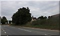
1

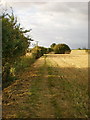
Arable land north of Churchgate Street
Image: © Alexander P Kapp
Taken: 14 Sep 2009
0.07 miles
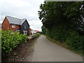
2
Footpath
From the B183 to the River Stort
Image: © Alexander P Kapp
Taken: 14 Sep 2009
0.11 miles
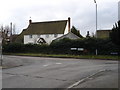
5
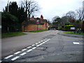
Road junction
The junction of the B183 and Sheering Road.
Image: © Alexander P Kapp
Taken: 27 Dec 2007
0.20 miles
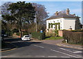
6
Village scene, Churchgate Street
Where Churchgate Street turns right into Sheering Road.
Image: © Andrew Hill
Taken: 22 Mar 2009
0.22 miles
8
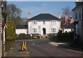
Large house, Churchgate Street
By the corner of Churchgate Street with Sheering Road.
Image: © Andrew Hill
Taken: 22 Mar 2009
0.22 miles
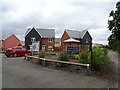
10
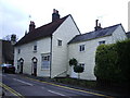
Nos 2-6 Churchgate Street, Harlow
Image: © Alexander P Kapp
Taken: 27 Dec 2007
0.25 miles