IMAGES TAKEN NEAR TO
Mulberry Green, HARLOW, CM17 0EZ
Introduction
This page details the photographs taken nearby to Mulberry Green, CM17 0EZ by members of the Geograph project.
The Geograph project started in 2005 with the aim of publishing, organising and preserving representative images for every square kilometre of Great Britain, Ireland and the Isle of Man.

There are currently over 7.5m images from over14,400 individuals and you can help contribute to the project by visiting https://www.geograph.org.uk
Image Map
Images are licensed for reuse under creativecommons.org/licenses/by-sa/2.0
Notes
- Clicking on the map will re-center to the selected point.
- The higher the marker number, the further away the image location is from the centre of the postcode.
Image Listing (75 Images Found)
Images are licensed for reuse under creativecommons.org/licenses/by-sa/2.0
Image
Details
Distance
1
Direction signs on Gilden Way, Churchgate Street
The fence arrived in the last few months
Image: © David Howard
Taken: 13 Jul 2019
0.03 miles
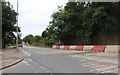
3
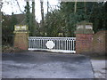
Old county council bridge
Bypassed when Gilden Way was built
Image: © Alexander P Kapp
Taken: 5 Mar 2009
0.05 miles
4
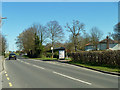
Oxleys bus stop
Looking from the bus stop away from Harlow to the one towards it.
Image: © Robin Webster
Taken: 16 Mar 2014
0.09 miles
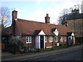
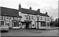
8
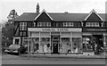
Samuel Young, Mulberry Green
A ladies clothing shop in Old Harlow with, next door, Chapman's hardware shop.
Image: © Penny Mayes
Taken: 1 Jan 1971
0.15 miles