IMAGES TAKEN NEAR TO
Petunia Crescent, CHELMSFORD, CM1 6YP
Introduction
This page details the photographs taken nearby to Petunia Crescent, CM1 6YP by members of the Geograph project.
The Geograph project started in 2005 with the aim of publishing, organising and preserving representative images for every square kilometre of Great Britain, Ireland and the Isle of Man.

There are currently over 7.5m images from over14,400 individuals and you can help contribute to the project by visiting https://www.geograph.org.uk
Image Map
Images are licensed for reuse under creativecommons.org/licenses/by-sa/2.0
Notes
- Clicking on the map will re-center to the selected point.
- The higher the marker number, the further away the image location is from the centre of the postcode.
Image Listing (8 Images Found)
Images are licensed for reuse under creativecommons.org/licenses/by-sa/2.0
Image
Details
Distance
1
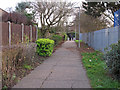
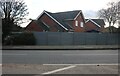
Footpath near Primary School, Springfield, Chelmsford
Image: © Roger Jones
Taken: 29 Dec 2018
0.08 miles
2
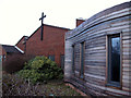
St Augustine of Canterbury RC Church Chelmsford Essex
Situated in New Bowers Way, Springfield, Chelmsford.
Image: © Peter Stack
Taken: 26 Jan 2008
0.16 miles
3
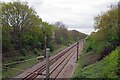
Next Stop Chelmsford
Unless of course you are going in the opposite direction! Then it could be Hatfield Peverel for an "all stations" train.
Image: © Glyn Baker
Taken: 13 Apr 2017
0.18 miles
4
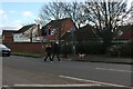
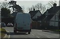
Pedestrian crossing on White Hart Lane, Chelmsford
Image: © David Howard
Taken: 6 Feb 2022
0.22 miles
6
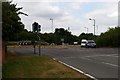
Roundabout in Springfield
This is the Junction of the A130 White Hart Lane, New Bowers Way and Beaulieu boulevard near Springfield in Chelmsford
Image: © Glyn Baker
Taken: 6 Aug 2006
0.23 miles
7
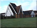
North Springfield Baptist Church Chelmsford Essex
Situated in Havengore, Springfield, Chelmsford.
Image: © Peter Stack
Taken: 26 Jan 2008
0.23 miles