IMAGES TAKEN NEAR TO
Leybourne Drive, CHELMSFORD, CM1 6TX
Introduction
This page details the photographs taken nearby to Leybourne Drive, CM1 6TX by members of the Geograph project.
The Geograph project started in 2005 with the aim of publishing, organising and preserving representative images for every square kilometre of Great Britain, Ireland and the Isle of Man.

There are currently over 7.5m images from over14,400 individuals and you can help contribute to the project by visiting https://www.geograph.org.uk
Image Map
Images are licensed for reuse under creativecommons.org/licenses/by-sa/2.0
Notes
- Clicking on the map will re-center to the selected point.
- The higher the marker number, the further away the image location is from the centre of the postcode.
Image Listing (7 Images Found)
Images are licensed for reuse under creativecommons.org/licenses/by-sa/2.0
Image
Details
Distance
1
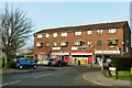
Local shops, Springfield
On Clematis Tye.
Image: © Robin Webster
Taken: 11 Dec 2012
0.09 miles
2

The Gardeners - inn sign
The '1799' logo is the only external indication anywhere on the pub that this is a Greene King house. Is there still local hostility after they took over Ridleys and closed the brewery down?
Image: © Robin Webster
Taken: 11 Dec 2012
0.09 miles
3
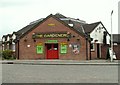
'The Gardeners' public house
The road in the picture is Crocus Way.
Image: © Robert Edwards
Taken: 30 May 2008
0.13 miles
4
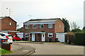
Semi-detached on Knapton Close
In the northern part of the fairly recent spread of the north-eastern or Springfield sector of Chelmsford.
Image: © Robin Webster
Taken: 11 Dec 2012
0.21 miles
5
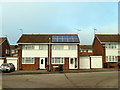
Semi-detached on Briarswood
Blessed with a south facing roof with an unobstructed view of the sun, ideal for solar panels.
Image: © Robin Webster
Taken: 11 Dec 2012
0.22 miles
6
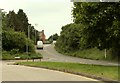
Lawn Lane in Springfield
The turning on the left is Waveney Drive.
Image: © Robert Edwards
Taken: 30 May 2008
0.22 miles
7
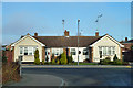
Bungalows on Sidmouth Road
Opposite the end of Dartmouth Road. The roads in this part of Springfield have West Country names.
Image: © Robin Webster
Taken: 11 Dec 2012
0.24 miles