IMAGES TAKEN NEAR TO
Stirrup Close, CHELMSFORD, CM1 6ST
Introduction
This page details the photographs taken nearby to Stirrup Close, CM1 6ST by members of the Geograph project.
The Geograph project started in 2005 with the aim of publishing, organising and preserving representative images for every square kilometre of Great Britain, Ireland and the Isle of Man.

There are currently over 7.5m images from over14,400 individuals and you can help contribute to the project by visiting https://www.geograph.org.uk
Image Map
Images are licensed for reuse under creativecommons.org/licenses/by-sa/2.0
Notes
- Clicking on the map will re-center to the selected point.
- The higher the marker number, the further away the image location is from the centre of the postcode.
Image Listing (10 Images Found)
Images are licensed for reuse under creativecommons.org/licenses/by-sa/2.0
Image
Details
Distance
1
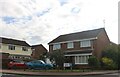
Carriage Drive, Springfield, Chelmsford
Image: © David Howard
Taken: 25 Aug 2024
0.09 miles
2
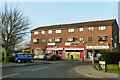
Local shops, Springfield
On Clematis Tye.
Image: © Robin Webster
Taken: 11 Dec 2012
0.19 miles
3
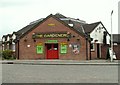
'The Gardeners' public house
The road in the picture is Crocus Way.
Image: © Robert Edwards
Taken: 30 May 2008
0.20 miles
5
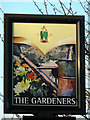
The Gardeners - inn sign
The '1799' logo is the only external indication anywhere on the pub that this is a Greene King house. Is there still local hostility after they took over Ridleys and closed the brewery down?
Image: © Robin Webster
Taken: 11 Dec 2012
0.22 miles
6
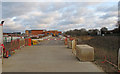
Beaulieu Construction Site, Springfield, Chelmsford
Part of the Greater Beaulieu Park development.
Image: © Roger Jones
Taken: 29 Dec 2018
0.23 miles
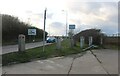
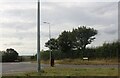
7

Chelmer Valley Road, Chelmsford
This is on the northern fringe of the city, which was given its status for the Queen's golden jubilee in 2012.
Image: © David Howard
Taken: 12 Nov 2023
0.23 miles
8
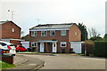
Semi-detached on Knapton Close
In the northern part of the fairly recent spread of the north-eastern or Springfield sector of Chelmsford.
Image: © Robin Webster
Taken: 11 Dec 2012
0.24 miles
9
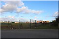
Beaulieu Park School playing fields
I hope the housing estate going up on the left isn't going to take over any of them.
Image: © David Howard
Taken: 6 Feb 2022
0.24 miles
10
Nabbotts Farm Roundabout on White Hart Lane, Springfield, Chelmsford
Image: © David Howard
Taken: 25 Aug 2024
0.25 miles