IMAGES TAKEN NEAR TO
Mimosa Close, CHELMSFORD, CM1 6NW
Introduction
This page details the photographs taken nearby to Mimosa Close, CM1 6NW by members of the Geograph project.
The Geograph project started in 2005 with the aim of publishing, organising and preserving representative images for every square kilometre of Great Britain, Ireland and the Isle of Man.

There are currently over 7.5m images from over14,400 individuals and you can help contribute to the project by visiting https://www.geograph.org.uk
Image Map (Loading...)


Getting Data...Please wait
Leaflet Map data © OpenStreetMap
Images are licensed for reuse under creativecommons.org/licenses/by-sa/2.0
Notes
- Clicking on the map will re-center to the selected point.
- The higher the marker number, the further away the image location is from the centre of the postcode.
Image Listing (7 Images Found)
Images are licensed for reuse under creativecommons.org/licenses/by-sa/2.0
Image
Details
Distance
2
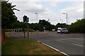
Roundabout in Springfield
This is the Junction of the A130 White Hart Lane, New Bowers Way and Beaulieu boulevard near Springfield in Chelmsford
Image: © Glyn Baker
Taken: 6 Aug 2006
0.06 miles
3
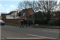
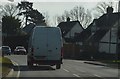
Pedestrian crossing on White Hart Lane, Chelmsford
Image: © David Howard
Taken: 6 Feb 2022
0.08 miles
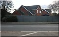
4
Public Footpath !!???
According to both my maps this waymarked footpath passes through open fields. It now passes through a development of properties the style of which endorses all those Essex man/girl jokes ("plastic" weatherboarding ugh!).
Image: © Glyn Baker
Taken: 6 Aug 2006
0.13 miles
5
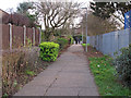
Footpath near Primary School, Springfield, Chelmsford
Image: © Roger Jones
Taken: 29 Dec 2018
0.15 miles
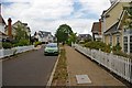
7
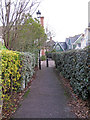
Path near Frances Green, Springfield, Chelmsford
Image: © Roger Jones
Taken: 29 Dec 2018
0.19 miles