IMAGES TAKEN NEAR TO
Abridge Road, EPPING, CM16 7NP
Introduction
This page details the photographs taken nearby to Abridge Road, CM16 7NP by members of the Geograph project.
The Geograph project started in 2005 with the aim of publishing, organising and preserving representative images for every square kilometre of Great Britain, Ireland and the Isle of Man.

There are currently over 7.5m images from over14,400 individuals and you can help contribute to the project by visiting https://www.geograph.org.uk
Image Map
Images are licensed for reuse under creativecommons.org/licenses/by-sa/2.0
Notes
- Clicking on the map will re-center to the selected point.
- The higher the marker number, the further away the image location is from the centre of the postcode.
Image Listing (28 Images Found)
Images are licensed for reuse under creativecommons.org/licenses/by-sa/2.0
Image
Details
Distance
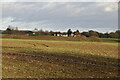
5
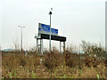
Sign gantry on M11
This is over the northbound carriageway, 1/2 mile before the M25 intersection.
Image: © Robin Webster
Taken: 1 Apr 2013
0.07 miles
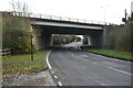
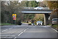
8
M11 bridge over Abridge Road (B172)
Near right is the entrance to Theydon Cemetery.
Image: © Robin Webster
Taken: 1 Apr 2013
0.08 miles
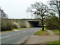
10
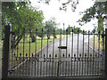
Cemetery gates
Well kept cemetery with attractive entrance
Image: © Linda Craven
Taken: 12 Aug 2006
0.10 miles