IMAGES TAKEN NEAR TO
Dukes Avenue, EPPING, CM16 7HQ
Introduction
This page details the photographs taken nearby to Dukes Avenue, CM16 7HQ by members of the Geograph project.
The Geograph project started in 2005 with the aim of publishing, organising and preserving representative images for every square kilometre of Great Britain, Ireland and the Isle of Man.

There are currently over 7.5m images from over14,400 individuals and you can help contribute to the project by visiting https://www.geograph.org.uk
Image Map (Loading...)


Getting Data...Please wait
Leaflet Map data © OpenStreetMap
Images are licensed for reuse under creativecommons.org/licenses/by-sa/2.0
Notes
- Clicking on the map will re-center to the selected point.
- The higher the marker number, the further away the image location is from the centre of the postcode.
Image Listing (4 Images Found)
Images are licensed for reuse under creativecommons.org/licenses/by-sa/2.0
Image
Details
Distance
1
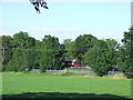
Rural Tube, Theydon Bois
London Underground's Central Line passes through countryside as it heads into Essex. The Underground is often referred to as the Tube, as the busiest parts of the system through Central London are in tunnel.
Image: © Malc McDonald
Taken: 24 Jul 2011
0.17 miles
2
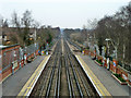
Central line north of Theydon Bois
Theydon Bois and the next and final station, Epping, are both in London travel zone 6, which is unusual (and very handy) as this zone does not extend beyond Greater London as a general rule, but these stations are in Essex.
Image: © Robin Webster
Taken: 1 Apr 2013
0.18 miles
3

Dead tree
On a low hill in a field of pasture to the east of Little Gregories.
Image: © Trevor Harris
Taken: 14 Mar 2021
0.22 miles
4
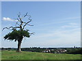
Tree overlooking Theydon Bois
A solitary tree on a hilltop overlooking the village of Theydon Bois in Essex.
Image: © Malc McDonald
Taken: 24 Jul 2011
0.23 miles