IMAGES TAKEN NEAR TO
Coppice Row, EPPING, CM16 7DR
Introduction
This page details the photographs taken nearby to Coppice Row, CM16 7DR by members of the Geograph project.
The Geograph project started in 2005 with the aim of publishing, organising and preserving representative images for every square kilometre of Great Britain, Ireland and the Isle of Man.

There are currently over 7.5m images from over14,400 individuals and you can help contribute to the project by visiting https://www.geograph.org.uk
Image Map (Loading...)


Getting Data...Please wait
Leaflet Map data © OpenStreetMap
Images are licensed for reuse under creativecommons.org/licenses/by-sa/2.0
Notes
- Clicking on the map will re-center to the selected point.
- The higher the marker number, the further away the image location is from the centre of the postcode.
Image Listing (8 Images Found)
Images are licensed for reuse under creativecommons.org/licenses/by-sa/2.0
Image
Details
Distance
1
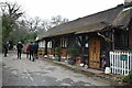
Oak Hill West Lodge
On the track leading to Birch Hall and Birch Hall Farm.
Image: © Trevor Harris
Taken: 14 Mar 2021
0.06 miles
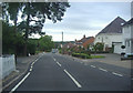
3
Footpath entrance
Leading to Debden Green
Image: © Roger Jones
Taken: 10 Jul 2011
0.08 miles
4
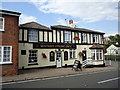
Sixteen String Jack
For a history of the pub, and how it got its name see http://www.sixteenstringjack.co.uk/the-history.php
Image: © Roger Jones
Taken: 10 Jul 2011
0.12 miles
5
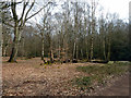
Group of birches, Epping Forest
Near the well-surfaced path to Theydon Bois.
Image: © Robin Webster
Taken: 1 Apr 2013
0.20 miles
6
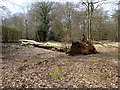
Fallen beech, Epping Forest
Near the B172 road, just visible beyond.
Image: © Robin Webster
Taken: 1 Apr 2013
0.20 miles
7

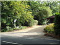
Tipi branches
Cut branches arranged in a tipi like fashion in this small clearing.
Image: © Roger Jones
Taken: 10 Jul 2011
0.22 miles
8
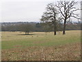
Deer Sanctuary near Theydon Bois
Taken from the wood to the South East of the sanctuary, one of the less visited parts of Epping Forest.
Image: © Andrew Dann
Taken: 18 Feb 2006
0.25 miles