IMAGES TAKEN NEAR TO
Allnutts Road, EPPING, CM16 7BE
Introduction
This page details the photographs taken nearby to Allnutts Road, CM16 7BE by members of the Geograph project.
The Geograph project started in 2005 with the aim of publishing, organising and preserving representative images for every square kilometre of Great Britain, Ireland and the Isle of Man.

There are currently over 7.5m images from over14,400 individuals and you can help contribute to the project by visiting https://www.geograph.org.uk
Image Map (Loading...)


Getting Data...Please wait
Leaflet Map data © OpenStreetMap
Images are licensed for reuse under creativecommons.org/licenses/by-sa/2.0
Notes
- Clicking on the map will re-center to the selected point.
- The higher the marker number, the further away the image location is from the centre of the postcode.
Image Listing (40 Images Found)
Images are licensed for reuse under creativecommons.org/licenses/by-sa/2.0
Image
Details
Distance
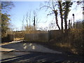
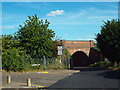
2
Railway bridge on Brook Road
This is the other side of the bridge also seen in Image Note the sharp bend immediately beyond the bridge: it is surprising that there is no form of traffic control here, or even a priority to traffic coming down the hill.
The bridge carries the Central Line of London Transport just before its northern terminus at Epping station Image
Image: © Stephen Craven
Taken: 20 Mar 2009
0.07 miles
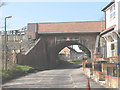
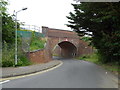
3
Railway bridge at Ivy Chimneys
The road approaching the bridge is Bridge Hill, which becomes Brook Road the other side of the bridge.
Image: © Robert Edwards
Taken: 18 Apr 2008
0.07 miles
4
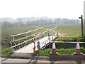
Footpath from Brook Lane towards Coopersale Hall
The start of the footpath had been diverted because of nearby engineering works on the railway embankment, hence the temporary bridge over a ditch.
Image: © Stephen Craven
Taken: 20 Mar 2009
0.07 miles
6
Railway bridge over Bridge Hill, Ivy Chimneys
Road becomes Brook Road the other side of the bridge.
Image: © JThomas
Taken: 6 Jul 2019
0.08 miles
7
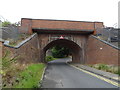
Railway bridge over Brook Road, Ivy Chimneys
Road becomes Bridge Hill on the other side of the bridge.
Image: © JThomas
Taken: 6 Jul 2019
0.08 miles
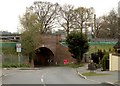
8
Railway bridge O87, Epping
Built by the Great Eastern Railway, now it carries the Central Line and is numbered using what is now the Transport for London system, the 'O' presumably standing for Ongar.
Image: © Robin Webster
Taken: 30 Apr 2016
0.08 miles
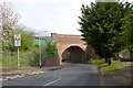
10
Bridge Hill, Epping
The bridge carries London Underground's Central Line across the road, a short distance from the Underground's terminus at Epping.
Image: © Malc McDonald
Taken: 7 Jun 2015
0.09 miles