IMAGES TAKEN NEAR TO
Allnutts Road, EPPING, CM16 7BD
Introduction
This page details the photographs taken nearby to Allnutts Road, CM16 7BD by members of the Geograph project.
The Geograph project started in 2005 with the aim of publishing, organising and preserving representative images for every square kilometre of Great Britain, Ireland and the Isle of Man.

There are currently over 7.5m images from over14,400 individuals and you can help contribute to the project by visiting https://www.geograph.org.uk
Image Map (Loading...)


Getting Data...Please wait
Leaflet Map data © OpenStreetMap
Images are licensed for reuse under creativecommons.org/licenses/by-sa/2.0
Notes
- Clicking on the map will re-center to the selected point.
- The higher the marker number, the further away the image location is from the centre of the postcode.
Image Listing (49 Images Found)
Images are licensed for reuse under creativecommons.org/licenses/by-sa/2.0
Image
Details
Distance
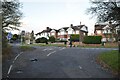
3
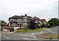
Houses on Brook Road
At the junction with Bower Hill.
Image: © JThomas
Taken: 6 Jul 2019
0.08 miles
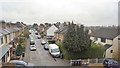
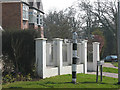
4
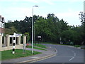
Road junction near Epping
A bend in the road and a traditional direction sign.
Image: © Malc McDonald
Taken: 3 Sep 2011
0.09 miles
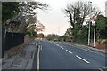
5
Road junction near Epping
A road junction near Epping in Essex.
Image: © Malc McDonald
Taken: 3 Sep 2011
0.09 miles
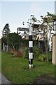
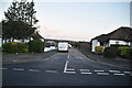
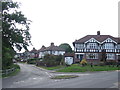
8
Old signpost, Bower Hill
The black-and-white painted signpost is at the junction of Bower Hill and Brook Road.
Image: © Stephen Craven
Taken: 20 Mar 2009
0.10 miles