IMAGES TAKEN NEAR TO
Elm Gardens, EPPING, CM16 6DR
Introduction
This page details the photographs taken nearby to Elm Gardens, CM16 6DR by members of the Geograph project.
The Geograph project started in 2005 with the aim of publishing, organising and preserving representative images for every square kilometre of Great Britain, Ireland and the Isle of Man.

There are currently over 7.5m images from over14,400 individuals and you can help contribute to the project by visiting https://www.geograph.org.uk
Image Map (Loading...)


Getting Data...Please wait
Leaflet Map data © OpenStreetMap
Images are licensed for reuse under creativecommons.org/licenses/by-sa/2.0
Notes
- Clicking on the map will re-center to the selected point.
- The higher the marker number, the further away the image location is from the centre of the postcode.
Image Listing (27 Images Found)
Images are licensed for reuse under creativecommons.org/licenses/by-sa/2.0
Image
Details
Distance
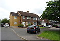
1
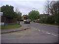
Elm Gardens at the junction of High Road North Weald Bassett
Image: © David Howard
Taken: 2 May 2012
0.02 miles
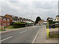
4
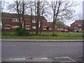
Houses along High Road, North Weald Bassett
These sort of houses are typical of estates built around the 1970s and had the good sense to include a good deal of green space around them instead of cramming them all together.
Image: © David Howard
Taken: 2 May 2012
0.03 miles
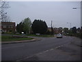
5
Houses on Harrison Drive, North Weald Bassett
Image: © JThomas
Taken: 6 Jul 2019
0.05 miles
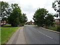
6
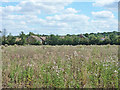
Houses across a field of thistles, North Weald Bassett
This was an attempt to replicate an old view by John Piper in the Tate Archive. See http://www.tate.org.uk/art/archive/tga-8728-1-12-91/piper-photograph-of-a-countryside-landscape-with-houses-possibly-in-essex
The visible houses are mainly on Harrison Drive. Needless to say, the radio station is now demolished. The missing large tree looks like it was an Elm.
Image: © Robin Webster
Taken: 17 Aug 2015
0.08 miles
7
Shops on High Road, North Weald village
Image: © Nigel Thompson
Taken: 22 Apr 2023
0.08 miles
8
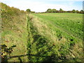
North Weald Bassett Drain
The drain takes water down from Image which is at the top of the hill.
Image: © Nigel Cox
Taken: 27 Oct 2010
0.11 miles
9
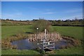
Sluice in Weald Common
This pond is part of a flood flood alleviation scheme it is also part of a local nature reserve see http://www.wildessex.net/sites/Weald%20Common%20Flood%20Meadows.htm for more info
Image: © Glyn Baker
Taken: 20 Apr 2016
0.12 miles
10
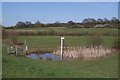
North Weald Flood Meadow
The North Weald Flood Meadows was created 1996 as part of a flood alleviation scheme
they are managed by Epping Council as part of Image see http://www.wildessex.net/sites/Weald%20Common%20Flood%20Meadows.htm for more information
Image: © Glyn Baker
Taken: 20 Apr 2016
0.12 miles