IMAGES TAKEN NEAR TO
Bassett Gardens, EPPING, CM16 6DB
Introduction
This page details the photographs taken nearby to Bassett Gardens, CM16 6DB by members of the Geograph project.
The Geograph project started in 2005 with the aim of publishing, organising and preserving representative images for every square kilometre of Great Britain, Ireland and the Isle of Man.

There are currently over 7.5m images from over14,400 individuals and you can help contribute to the project by visiting https://www.geograph.org.uk
Image Map (Loading...)


Getting Data...Please wait
Leaflet Map data © OpenStreetMap
Images are licensed for reuse under creativecommons.org/licenses/by-sa/2.0
Notes
- Clicking on the map will re-center to the selected point.
- The higher the marker number, the further away the image location is from the centre of the postcode.
Image Listing (31 Images Found)
Images are licensed for reuse under creativecommons.org/licenses/by-sa/2.0
Image
Details
Distance
1
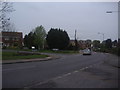
Shops on High Road, North Weald village
Image: © Nigel Thompson
Taken: 22 Apr 2023
0.04 miles
2
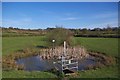
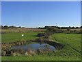
Sluice in Weald Common
This pond is part of a flood flood alleviation scheme it is also part of a local nature reserve see http://www.wildessex.net/sites/Weald%20Common%20Flood%20Meadows.htm for more info
Image: © Glyn Baker
Taken: 20 Apr 2016
0.06 miles
3
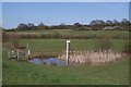
North Weald Flood Meadow
The North Weald Flood Meadows was created 1996 as part of a flood alleviation scheme
they are managed by Epping Council as part of Image see http://www.wildessex.net/sites/Weald%20Common%20Flood%20Meadows.htm for more information
Image: © Glyn Baker
Taken: 20 Apr 2016
0.06 miles
4
North Weald Common, Essex
A view to the east over what used to be the 2nd World War location of the North Weald Wireless Station - now a community open space. http://www.subbrit.org.uk/sb-sites/sites/n/north_weald_ongar_radio/index.shtml
Image: © John Winfield
Taken: 17 Nov 2005
0.08 miles
5
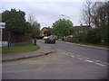
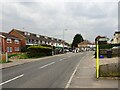
Elm Gardens at the junction of High Road North Weald Bassett
Image: © David Howard
Taken: 2 May 2012
0.08 miles
6
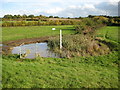
North Weald Bassett: Lower Thornhill Flood Storage Area
There are several flood storage areas around North Weald Bassett. This one would contain water coming from the south-east side of the village in a flood event. This image was an unintentional near-repeat of John's Image from almost exactly five years previously, both having been taken from on top of the flood storage area impounding embankment. Spot the differences and in particular how the flood storage area pond is actively managed!
This flood storage area was constructed in 1996 and is now Epping Forest District Council's Weald Common Flood Meadows Local Nature Reserve.
Image: © Nigel Cox
Taken: 27 Oct 2010
0.08 miles
8
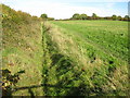
North Weald Bassett Drain
The drain takes water down from Image which is at the top of the hill.
Image: © Nigel Cox
Taken: 27 Oct 2010
0.09 miles
9
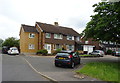
Houses on Harrison Drive, North Weald Bassett
Image: © JThomas
Taken: 6 Jul 2019
0.09 miles