IMAGES TAKEN NEAR TO
Weald Bridge Road, EPPING, CM16 6AT
Introduction
This page details the photographs taken nearby to Weald Bridge Road, CM16 6AT by members of the Geograph project.
The Geograph project started in 2005 with the aim of publishing, organising and preserving representative images for every square kilometre of Great Britain, Ireland and the Isle of Man.

There are currently over 7.5m images from over14,400 individuals and you can help contribute to the project by visiting https://www.geograph.org.uk
Image Map (Loading...)


Getting Data...Please wait
Leaflet Map data © OpenStreetMap
Images are licensed for reuse under creativecommons.org/licenses/by-sa/2.0
Notes
- Clicking on the map will re-center to the selected point.
- The higher the marker number, the further away the image location is from the centre of the postcode.
Image Listing (17 Images Found)
Images are licensed for reuse under creativecommons.org/licenses/by-sa/2.0
Image
Details
Distance
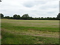
1
Ripening crop, Weald Bridge
Off Weald Bridge Road.
Image: © JThomas
Taken: 6 Jul 2019
0.05 miles
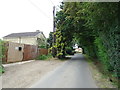
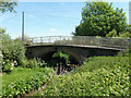
2
Weald Bridge
Looking towards Weald Bridge Farm.
Image: © Glyn Baker
Taken: 28 May 2020
0.09 miles
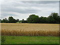
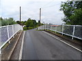
3
Weald Bridge
Weald Bridge Road crosses Cripsey Brook.
Image: © Robin Webster
Taken: 5 Jun 2013
0.09 miles
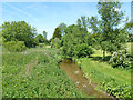
5
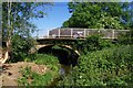
Weald Bridge Over Cripsey Brook
Looking downstream
Image: © Glyn Baker
Taken: 28 May 2020
0.09 miles
6
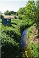
Thames Water Gauging Station, Cripsey Brook
Looking upstream from Image
Image: © Glyn Baker
Taken: 28 May 2020
0.09 miles
7
Cripsey Brook
Upstream from Weald Bridge.
Image: © Robin Webster
Taken: 5 Jun 2013
0.10 miles
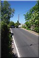
8
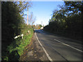
Weald Bridge, Magdalen Laver, Essex
A view north in Weald Bridge Road
Image: © John Winfield
Taken: 17 Nov 2005
0.13 miles