IMAGES TAKEN NEAR TO
Lower Swaines, EPPING, CM16 5ER
Introduction
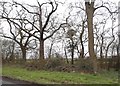
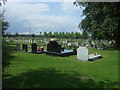
This page details the photographs taken nearby to Lower Swaines, CM16 5ER by members of the Geograph project.
The Geograph project started in 2005 with the aim of publishing, organising and preserving representative images for every square kilometre of Great Britain, Ireland and the Isle of Man.

There are currently over 7.5m images from over14,400 individuals and you can help contribute to the project by visiting https://www.geograph.org.uk
Image Map
Images are licensed for reuse under creativecommons.org/licenses/by-sa/2.0
Notes
- Clicking on the map will re-center to the selected point.
- The higher the marker number, the further away the image location is from the centre of the postcode.
Image Listing (7 Images Found)
Images are licensed for reuse under creativecommons.org/licenses/by-sa/2.0
Image
Details
Distance
7
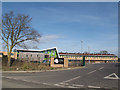
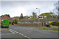
St John's new school, Epping
The grid reference has to be approximate as this new faith school does not yet appear on any maps. It opened in September 2013 to replace the existing school nearby. Its website http://www.eppingstjohns.org claims it is the first new secondary school in Epping in 50 years.
Image: © Stephen Craven
Taken: 15 Mar 2014
0.24 miles