IMAGES TAKEN NEAR TO
Lincolns Field, EPPING, CM16 5DY
Introduction
This page details the photographs taken nearby to Lincolns Field, CM16 5DY by members of the Geograph project.
The Geograph project started in 2005 with the aim of publishing, organising and preserving representative images for every square kilometre of Great Britain, Ireland and the Isle of Man.

There are currently over 7.5m images from over14,400 individuals and you can help contribute to the project by visiting https://www.geograph.org.uk
Image Map
Images are licensed for reuse under creativecommons.org/licenses/by-sa/2.0
Notes
- Clicking on the map will re-center to the selected point.
- The higher the marker number, the further away the image location is from the centre of the postcode.
Image Listing (6 Images Found)
Images are licensed for reuse under creativecommons.org/licenses/by-sa/2.0
Image
Details
Distance
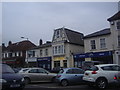
5

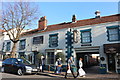
On the High Street at Epping
These appear to once have been elegant brick and timber houses, before being converted to business use.
Image: © David Martin
Taken: 18 Feb 2017
0.25 miles