IMAGES TAKEN NEAR TO
Stonards Hill, EPPING, CM16 4QJ
Introduction
This page details the photographs taken nearby to Stonards Hill, CM16 4QJ by members of the Geograph project.
The Geograph project started in 2005 with the aim of publishing, organising and preserving representative images for every square kilometre of Great Britain, Ireland and the Isle of Man.

There are currently over 7.5m images from over14,400 individuals and you can help contribute to the project by visiting https://www.geograph.org.uk
Image Map
Images are licensed for reuse under creativecommons.org/licenses/by-sa/2.0
Notes
- Clicking on the map will re-center to the selected point.
- The higher the marker number, the further away the image location is from the centre of the postcode.
Image Listing (28 Images Found)
Images are licensed for reuse under creativecommons.org/licenses/by-sa/2.0
Image
Details
Distance
1

Meadow Brown?
A rather care worn butterfly with my best guess as an I.D
Image: © Glyn Baker
Taken: 28 Jul 2016
0.09 miles
2
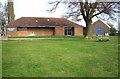
The Jack Silley Pavilion
The pavilion is in Stonards Hill recreational Ground. It is used for many activities throughout the year, including playschemes and public meetings. On the right is The Epping Town Band Room.
Image: © Lynda Poulter
Taken: 13 Apr 2007
0.15 miles
3

Tennis court and Band Room
Part of Stonards Hill recreational ground, showing the public tennis courts. The building is Epping Town Bands practice room.
Image: © Lynda Poulter
Taken: 13 Apr 2007
0.15 miles
4
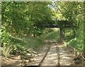
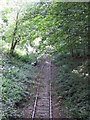
Disused railway, Epping
Epping is now the terminus of London Underground's Central Line. The line used to continue beyond Epping, through Essex countryside to Ongar. The line to Ongar closed in 1994.
This image, taken a short distance beyond the Epping terminus, shows traces of this line having once been part of London Underground. The Underground uses a third- and fourth-rail electrification system, with the fourth rail being in the centre of the tracks. Although the third and fourth rails have been removed here, the insulation pots which carried them, both in the centre and on the right-hand side of the tracks, are still there.
A preservation society has been established to operate trains on the Epping to Ongar Railway. Their website is here: http://eorailway.co.uk/
Image: © Malc McDonald
Taken: 3 Sep 2011
0.16 miles
5
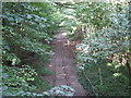
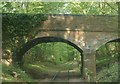
View of the Stonards Hill bridge from the Epping to Ongar Railway
This shot was taken looking through the cab of the Class 117 diesel railcar, looking south-southwest.
Image: © Robert Lamb
Taken: 23 Apr 2017
0.17 miles
6
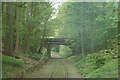
View of the footbridge from the Epping to Ongar Railway #2
Looking north-northeast.
Image: © Robert Lamb
Taken: 23 Apr 2017
0.17 miles
7
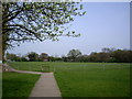
Football Pitch
Within Stonards Hill recreational Ground, this is the home pitch of Epping Town Football Team.
Image: © Lynda Poulter
Taken: 13 Apr 2007
0.18 miles
8
View of the Stonards Hill bridge from the Epping to Ongar Railway #2
Looking north-northeast.
Image: © Robert Lamb
Taken: 23 Apr 2017
0.18 miles
9
Disused railway, Epping
Epping is now the terminus of London Underground's Central Line. The line used to continue beyond Epping, through Essex countryside to Ongar. The line to Ongar closed in 1994.
This image, taken a short distance beyond the Epping terminus, shows traces of this line having once been part of London Underground. The Underground uses a third- and fourth-rail electrification system, with the fourth rail being in the centre of the tracks. Although the third and fourth rails have been removed here, the insulation pots which carried them, both in the centre and on the right-hand side of the tracks, are still there.
A preservation society has been established to operate trains on the Epping to Ongar Railway. Their website is here: http://eorailway.co.uk/
Image: © Malc McDonald
Taken: 3 Sep 2011
0.19 miles
10
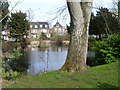
Pond at Theydon Grove
This pond is just off the High Street at the northern end of Epping, just before The Green is reached. The houses on the far side are on Theydon Grove.
Image: © Marathon
Taken: 13 Mar 2015
0.20 miles