IMAGES TAKEN NEAR TO
Amesbury Road, EPPING, CM16 4HY
Introduction
This page details the photographs taken nearby to Amesbury Road, CM16 4HY by members of the Geograph project.
The Geograph project started in 2005 with the aim of publishing, organising and preserving representative images for every square kilometre of Great Britain, Ireland and the Isle of Man.

There are currently over 7.5m images from over14,400 individuals and you can help contribute to the project by visiting https://www.geograph.org.uk
Image Map (Loading...)


Getting Data...Please wait
Leaflet Map data © OpenStreetMap
Images are licensed for reuse under creativecommons.org/licenses/by-sa/2.0
Notes
- Clicking on the map will re-center to the selected point.
- The higher the marker number, the further away the image location is from the centre of the postcode.
Image Listing (159 Images Found)
Images are licensed for reuse under creativecommons.org/licenses/by-sa/2.0
Image
Details
Distance
7
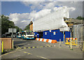
Epping Station
The northern end of London Underground's Central line serving the town of Epping and surrounding area. The line is a commuter link with central London. The station is currently being re-furbished.
Image: © Dennis Turner
Taken: 1 Sep 2006
0.11 miles
8
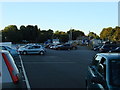
Car Park at Epping Station
The station building can be seen in the background
Image: © Oxyman
Taken: 4 Aug 2007
0.12 miles
9
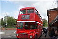
View of a Routemaster bus at Epping station #2
Looking north-northwest.
Image: © Robert Lamb
Taken: 23 Apr 2017
0.12 miles
10
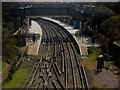
Epping Tube Station
View of Epping tube station from Bower Hill bridge.
Image: © Ed of the South
Taken: 2 Apr 2012
0.12 miles