IMAGES TAKEN NEAR TO
Station Road, EPPING, CM16 4HJ
Introduction
This page details the photographs taken nearby to Station Road, CM16 4HJ by members of the Geograph project.
The Geograph project started in 2005 with the aim of publishing, organising and preserving representative images for every square kilometre of Great Britain, Ireland and the Isle of Man.

There are currently over 7.5m images from over14,400 individuals and you can help contribute to the project by visiting https://www.geograph.org.uk
Image Map (Loading...)


Getting Data...Please wait
Leaflet Map data © OpenStreetMap
Images are licensed for reuse under creativecommons.org/licenses/by-sa/2.0
Notes
- Clicking on the map will re-center to the selected point.
- The higher the marker number, the further away the image location is from the centre of the postcode.
Image Listing (123 Images Found)
Images are licensed for reuse under creativecommons.org/licenses/by-sa/2.0
Image
Details
Distance
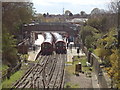
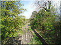
2

Disused Underground track, Epping
London Underground's Central Line extends beyond the London boundary to a terminus at Epping, in Essex. The line used to continue further still, to Ongar. The Ongar line closed in 1994.
This view, taken from a road bridge just north of Epping station, shows a disused siding (to the left) and the line to Ongar (to the right), with rails still intact but becoming overgrown.
Image: © Malc McDonald
Taken: 3 Sep 2011
0.05 miles
4
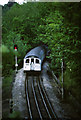
Underground approaching Epping
London Underground's Central Line now terminates at Epping. There used to be a shuttle service which ran onwards from Epping to Ongar mainly through countryside. The line to Ongar closed in 1994. This image shows a train from Ongar approaching Epping station.
For a more recent image taken from the same spot, see Image
Image: © Malc McDonald
Taken: 12 May 1989
0.05 miles
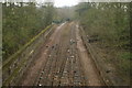
5
Disused tracks beyond Epping
The Central Line used to run to Ongar, 11km further north-east. It was closed in 1994, apart from occasional privately operated specials. As can be seen here the former down line has a physical stop barrier, but the up line retains a connection for occasional stock movements.
Image: © Stephen Craven
Taken: 20 Mar 2009
0.05 miles
6
Disused underground railway lines, Epping
Image: © Stacey Harris
Taken: 21 Apr 2012
0.05 miles
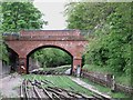
7
View of the former tube lines to Ongar from the Bower Hill bridge
Looking north-northeast.
Image: © Robert Lamb
Taken: 13 Apr 2018
0.06 miles
8
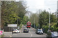
View of a Routemaster bus from Ongar coming down the hill to Epping Station
The Routemaster bus is operated by the Epping-Ongar railway, ferrying passengers to North Weald and Ongar stations, as there is no direct rail link between the railway and Epping station due to the fire hazard running steam trains on electric rails would present. Looking north-northeast.
Image: © Robert Lamb
Taken: 23 Apr 2017
0.06 miles
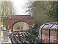
9
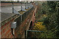
View along the Bower Hill bridge over the former tube tracks to Ongar
Looking south-southeast.
Image: © Robert Lamb
Taken: 13 Apr 2018
0.06 miles
10
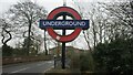
View of the Epping Station roundel from Station Road
Looking south-southeast.
Image: © Robert Lamb
Taken: 13 Apr 2018
0.06 miles