IMAGES TAKEN NEAR TO
Elizabeth Road, BRENTWOOD, CM15 9NU
Introduction
This page details the photographs taken nearby to Elizabeth Road, CM15 9NU by members of the Geograph project.
The Geograph project started in 2005 with the aim of publishing, organising and preserving representative images for every square kilometre of Great Britain, Ireland and the Isle of Man.

There are currently over 7.5m images from over14,400 individuals and you can help contribute to the project by visiting https://www.geograph.org.uk
Image Map
Images are licensed for reuse under creativecommons.org/licenses/by-sa/2.0
Notes
- Clicking on the map will re-center to the selected point.
- The higher the marker number, the further away the image location is from the centre of the postcode.
Image Listing (9 Images Found)
Images are licensed for reuse under creativecommons.org/licenses/by-sa/2.0
Image
Details
Distance
1
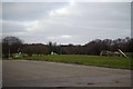
Bishops Hall Park
A Children's play area in the park.
Image: © Glyn Baker
Taken: 2 Mar 2013
0.10 miles
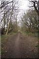
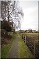
3
Green Lane
According to the map this is a by-way but the road signs clear motor vehicles are not welcome!
Image: © Glyn Baker
Taken: 2 Mar 2013
0.15 miles
4
Bishops Hall Road
Taken from Windsor Rd looking across King George Rd
Image: © Glyn Baker
Taken: 2 Mar 2013
0.17 miles
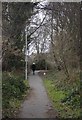
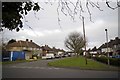
5
Elizabeth Road, Pilgrims Hatch
This looks west along Elizabeth Road across its junction with King George's Road.
Image: © Trevor Harris
Taken: 25 Sep 2008
0.19 miles
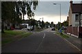
6
Towards King George Rd
Looking towards King George Rd & Image
Image: © Glyn Baker
Taken: 2 Mar 2013
0.21 miles
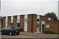
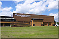
7
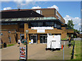
Entrance, the Brentwood Centre
A leisure centre.
Image: © Robin Webster
Taken: 30 Jun 2012
0.22 miles
8
International Hall, Brentwood Centre
No dropped H, but a dropped A.
Image: © Robin Webster
Taken: 30 Jun 2012
0.22 miles