IMAGES TAKEN NEAR TO
Merrymeade Chase, BRENTWOOD, CM15 9FE
Introduction
This page details the photographs taken nearby to Merrymeade Chase, CM15 9FE by members of the Geograph project.
The Geograph project started in 2005 with the aim of publishing, organising and preserving representative images for every square kilometre of Great Britain, Ireland and the Isle of Man.

There are currently over 7.5m images from over14,400 individuals and you can help contribute to the project by visiting https://www.geograph.org.uk
Image Map (Loading...)


Getting Data...Please wait
Leaflet Map data © OpenStreetMap
Images are licensed for reuse under creativecommons.org/licenses/by-sa/2.0
Notes
- Clicking on the map will re-center to the selected point.
- The higher the marker number, the further away the image location is from the centre of the postcode.
Image Listing (10 Images Found)
Images are licensed for reuse under creativecommons.org/licenses/by-sa/2.0
Image
Details
Distance
1
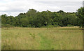
Open land at Merrymeade Country Park, Brentwood
Image: © Roger Jones
Taken: 30 Aug 2020
0.13 miles
2
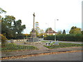
War Memorial near Brentwood
This war memorial stands at the junction of Shenfield Road and Middleton Hall Lane, near Brentwood.
Image: © Malc McDonald
Taken: 28 Oct 2017
0.15 miles
3
Leaving Brentwood on the Roman road
The Roman route to Colchester, which is not as straight as most Roman roads.
Image: © Robin Webster
Taken: 15 Sep 2011
0.16 miles
5
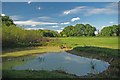
Pond in Merrymead Park
Merrymeade is 84 acres of country park adjacent to Brentwood and Shenfield it is managed by Brentwood Council for more info see http://www.brentwood.gov.uk/index.php?cid=1264 and http://www.wildessex.net/sites/Merrymeades%20Country%20Park.htm
Image: © Glyn Baker
Taken: 17 Oct 2010
0.19 miles
6
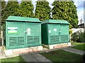
Electricity sub stations, Nuffield Hospital
Image: © Alex McGregor
Taken: 31 Jan 2013
0.21 miles
7
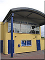
Brentwood Theatre, Shenfield Road, Brentwood, Essex
Described as an independent community theatre - specialises in productions for youth groups etc.
Image: © John Winfield
Taken: 6 Aug 2005
0.21 miles
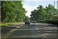
8

Shenfield Road, Brentwood
The A1023, before the bypass this was the A12, and a good deal before that, the Roman road to Colchester.
Image: © Robin Webster
Taken: 15 Sep 2011
0.23 miles
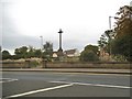
9
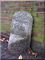
Old Milestone by the A1023, Shenfield Road, Brentwood
Metal plate attached to stone post by the A1023 (was A12), in parish of Brentwood (Brentwood District), Shenfield Road, by Brentwood Theatre, by the road, on North side of road. Erected by the Essex Second District turnpike trust in the 19th century.
Inscription once read:-
: (Ingatestone / V) : : (London / XVIII) : : (Romford / VI) :
Grade II listed.
List Entry Number: 1208026 https://historicengland.org.uk/listing/the-list/list-entry/1208026
Milestone Society National ID: EX_BWCH18
Image: © JV Nicholls
Taken: 25 Feb 2011
0.23 miles
10
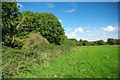
Merrymeade Scene
Merrymeade is 84 acres of country park adjacent to Brentwood and Shenfield it is managed by Brentwood Council for more info see http://www.brentwood.gov.uk/index.php?cid=1264 and http://www.wildessex.net/sites/Merrymeades%20Country%20Park.htm
Image: © Glyn Baker
Taken: 17 Oct 2010
0.25 miles