IMAGES TAKEN NEAR TO
Doddinghurst Road, BRENTWOOD, CM15 9EU
Introduction
This page details the photographs taken nearby to Doddinghurst Road, CM15 9EU by members of the Geograph project.
The Geograph project started in 2005 with the aim of publishing, organising and preserving representative images for every square kilometre of Great Britain, Ireland and the Isle of Man.

There are currently over 7.5m images from over14,400 individuals and you can help contribute to the project by visiting https://www.geograph.org.uk
Image Map
Images are licensed for reuse under creativecommons.org/licenses/by-sa/2.0
Notes
- Clicking on the map will re-center to the selected point.
- The higher the marker number, the further away the image location is from the centre of the postcode.
Image Listing (6 Images Found)
Images are licensed for reuse under creativecommons.org/licenses/by-sa/2.0
Image
Details
Distance
1
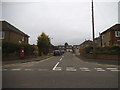
Rushdene Close at the junction of Doddinghurst Road
Image: © David Howard
Taken: 3 Sep 2017
0.04 miles
3
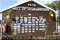
Wall of remembrance.
On the gable end of a stable row at Hopefield animal sanctuary.
Image: © william
Taken: 28 Sep 2008
0.12 miles
4
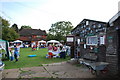
Open day at Hopefield
This is an animal sanctuary for unwanted, neglected or sick animals. There are horses, goats, sheep and pigs here.
Image: © william
Taken: 28 Sep 2008
0.13 miles
5
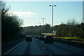
A12 Brentwood bypass westbound: approaching bridge under the A128
The houses to the right are on Hurstwood Avenue, part of which runs parallel to the top of the A12 cutting.
Image: © Christopher Hilton
Taken: 10 Dec 2022
0.22 miles
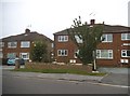
6
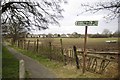
Footpath to King George Rd
The houses in the background are in Image
Image: © Glyn Baker
Taken: 2 Mar 2013
0.23 miles