IMAGES TAKEN NEAR TO
Tree Tops, BRENTWOOD, CM15 9DE
Introduction
This page details the photographs taken nearby to Tree Tops, CM15 9DE by members of the Geograph project.
The Geograph project started in 2005 with the aim of publishing, organising and preserving representative images for every square kilometre of Great Britain, Ireland and the Isle of Man.

There are currently over 7.5m images from over14,400 individuals and you can help contribute to the project by visiting https://www.geograph.org.uk
Image Map
Images are licensed for reuse under creativecommons.org/licenses/by-sa/2.0
Notes
- Clicking on the map will re-center to the selected point.
- The higher the marker number, the further away the image location is from the centre of the postcode.
Image Listing (12 Images Found)
Images are licensed for reuse under creativecommons.org/licenses/by-sa/2.0
Image
Details
Distance
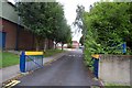
1
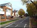
Highland Avenue, Brentwood
Highland Avenue in Brentwood, Essex
Image: © Malc McDonald
Taken: 28 Oct 2017
0.08 miles
2
Ongar Road at the corner of Western Avenue
Image: © David Howard
Taken: 3 Sep 2017
0.09 miles
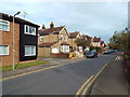
4
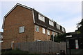
Terrace of houses by Ongar Road, Brentwood
The houses are on Wingway
Image: © David Howard
Taken: 25 May 2019
0.11 miles
5
Entrance to Sawyers Hall College, Brentwood.
This is one of the entrances to the comprehensive school, previously called Hedley Walter School.
Image: © Trevor Harris
Taken: 18 Aug 2008
0.13 miles
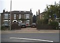
6
Burland Road, Brentwood
Burland Road is a residential road in Brentwood, Essex.
This image was taken in late October, when shadows were quite long.
Image: © Malc McDonald
Taken: 28 Oct 2017
0.14 miles
7
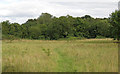
Open land at Merrymeade Country Park, Brentwood
Image: © Roger Jones
Taken: 30 Aug 2020
0.20 miles
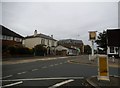
8
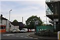
North Road at the junction of Ongar Road
Brentwood Kebab is on the corner
Image: © David Howard
Taken: 25 May 2019
0.22 miles
9
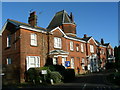
Highwood Hospital, Brentwood
Highwood Hospital is now a community hospital providing a variety of specialist medical services. It was built in 1904 as a charitable hospital for poor children with infectious diseases. Many of the buildings remain the same as can be seen on some of the original photos at http://www.workhouses.org.uk/index.html?MAB-HighWood/MAB-HighWood.shtml
Image: © John Winfield
Taken: 9 Nov 2006
0.22 miles
10
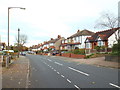
Western Avenue, Brentwood
Suburban housing on Western Avenue in Brentwood.
Image: © Malc McDonald
Taken: 28 Oct 2017
0.22 miles