IMAGES TAKEN NEAR TO
Ongar Road, BRENTWOOD, CM15 9AT
Introduction
This page details the photographs taken nearby to Ongar Road, CM15 9AT by members of the Geograph project.
The Geograph project started in 2005 with the aim of publishing, organising and preserving representative images for every square kilometre of Great Britain, Ireland and the Isle of Man.

There are currently over 7.5m images from over14,400 individuals and you can help contribute to the project by visiting https://www.geograph.org.uk
Image Map
Images are licensed for reuse under creativecommons.org/licenses/by-sa/2.0
Notes
- Clicking on the map will re-center to the selected point.
- The higher the marker number, the further away the image location is from the centre of the postcode.
Image Listing (81 Images Found)
Images are licensed for reuse under creativecommons.org/licenses/by-sa/2.0
Image
Details
Distance
1
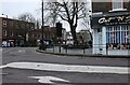
Ongar Road at the junction of High Street, Brentwood
Image: © David Howard
Taken: 1 Jan 2023
0.03 miles
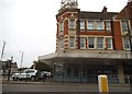
2
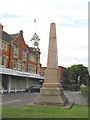
The William Hunter Memorial, Brentwood, Essex
This memorial marks the spot near Wilson's Corner Brentwood, where on 26th March 1555, William Hunter was burnt at the stake. Aged 19 years, his crime was to have been found reading the Bible in English!
Image: © John Winfield
Taken: 6 Aug 2005
0.03 miles
3
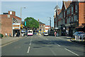
A128 Ingrave Road approaching Wilson's Corner
Wilsons were the original occupiers of the large corner building on the right.
Image: © Robin Webster
Taken: 15 Sep 2011
0.04 miles
4
Ongar Road at the junction of William Hunter Way
Image: © David Howard
Taken: 25 May 2019
0.04 miles
5
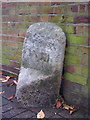
Old Milestone by the A1023, Shenfield Road, Brentwood
Metal plate attached to stone post by the A1023 (was A12), in parish of Brentwood (Brentwood District), Shenfield Road, by Brentwood Theatre, by the road, on North side of road. Erected by the Essex Second District turnpike trust in the 19th century.
Inscription once read:-
: (Ingatestone / V) : : (London / XVIII) : : (Romford / VI) :
Grade II listed.
List Entry Number: 1208026 https://historicengland.org.uk/listing/the-list/list-entry/1208026
Milestone Society National ID: EX_BWCH18
Image: © JV Nicholls
Taken: 25 Feb 2011
0.04 miles
6
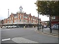
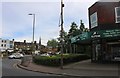
Brentwood High Street at the junction of Ingrave Road
Image: © David Howard
Taken: 3 Sep 2017
0.05 miles
7
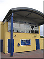
Brentwood Theatre, Shenfield Road, Brentwood, Essex
Described as an independent community theatre - specialises in productions for youth groups etc.
Image: © John Winfield
Taken: 6 Aug 2005
0.05 miles
8
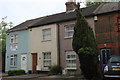
Terraced housing on Ongar Road, Brentwood
Image: © David Howard
Taken: 25 May 2019
0.05 miles
10

Shenfield Road, Brentwood
The A1023, before the bypass this was the A12, and a good deal before that, the Roman road to Colchester.
Image: © Robin Webster
Taken: 15 Sep 2011
0.06 miles