IMAGES TAKEN NEAR TO
Sebastian Avenue, BRENTWOOD, CM15 8PW
Introduction
This page details the photographs taken nearby to Sebastian Avenue, CM15 8PW by members of the Geograph project.
The Geograph project started in 2005 with the aim of publishing, organising and preserving representative images for every square kilometre of Great Britain, Ireland and the Isle of Man.

There are currently over 7.5m images from over14,400 individuals and you can help contribute to the project by visiting https://www.geograph.org.uk
Image Map
Images are licensed for reuse under creativecommons.org/licenses/by-sa/2.0
Notes
- Clicking on the map will re-center to the selected point.
- The higher the marker number, the further away the image location is from the centre of the postcode.
Image Listing (71 Images Found)
Images are licensed for reuse under creativecommons.org/licenses/by-sa/2.0
Image
Details
Distance
1
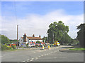
Chelmsford Road, Shenfield, Essex
Looking north-east towards the A12. The Rose Inn Public House on the left side of picture.
Image: © John Winfield
Taken: 15 Aug 2005
0.12 miles
2
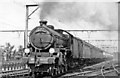
Up 'East Anglian' approaching Shenfield & Hutton, 1949
View NE, towards Chelmsford, Colchester etc. on the ex-GE main line, also Southend (Victoria) to the right. The wires were up here in June 1949, but the electric trains to Shenfield from Liverpool Street did not commence until 26/9/49 and to Southend in 1956, initially at 1,500v DC. (This was converted to 25kV (part at 6.25Kv) in 11/60 and eventually extended to Norwich. The recently introduced 'East Anglian', 09.45 from Yarmouth (Vauxhall) via Norwich and Ipswich, is speeding along towards London behind Thompson B1 4-6-0 No. 61332 (built 6/48, withdrawn 12/62).
Image: © Ben Brooksbank
Taken: 18 Jun 1949
0.13 miles
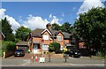
3
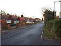
Hunter Avenue, Shenfield
Hunter Avenue in Shenfield, on a December afternoon.
Image: © Malc McDonald
Taken: 6 Dec 2014
0.13 miles
4
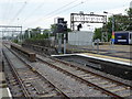
Looking north from Shenfield station
Shenfield station was opened by the Eastern Counties Railway company on 29th March 1843 on the extension from Brentwood to Colchester. It closed in March 1850 as passenger numbers were so low because there was little housing in the area. It was reopened with the name Shenfield & Hutton Junction on 1st January 1887 by the Great Eastern Railway to serve as an interchange station with the new line to Southend that was completed two years later. It was renamed Shenfield on 20th February 1969. From 2019 Shenfield will be the eastern end of Crossrail when it will be opened as the Elizabeth Line.
This view looks north from Platform 2. In about three quarters of a mile the line diverges with the 1843 line continuing to Chelmsford and Colchester while the 1889 line bears right for Billericay and Southend Victoria.
Image: © Marathon
Taken: 17 May 2017
0.15 miles
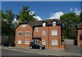
5
Alexander Lane, Shenfield
Alexander Lane in Shenfield, photographed on a sunny June afternoon.
Image: © Malc McDonald
Taken: 7 Jun 2015
0.15 miles
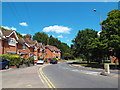
9
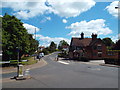
Rayleigh Road, Shenfield
Rayleigh Road, looking east. The pub on the opposite side of the road is The Hutton Junction.
Image: © Malc McDonald
Taken: 7 Jun 2015
0.16 miles
10
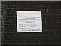
Railway sign on Hutton Road Railway Bridge
Image: © Geographer
Taken: 19 Sep 2015
0.17 miles