IMAGES TAKEN NEAR TO
Glendale Close, BRENTWOOD, CM15 8DB
Introduction
This page details the photographs taken nearby to Glendale Close, CM15 8DB by members of the Geograph project.
The Geograph project started in 2005 with the aim of publishing, organising and preserving representative images for every square kilometre of Great Britain, Ireland and the Isle of Man.

There are currently over 7.5m images from over14,400 individuals and you can help contribute to the project by visiting https://www.geograph.org.uk
Image Map
Images are licensed for reuse under creativecommons.org/licenses/by-sa/2.0
Notes
- Clicking on the map will re-center to the selected point.
- The higher the marker number, the further away the image location is from the centre of the postcode.
Image Listing (11 Images Found)
Images are licensed for reuse under creativecommons.org/licenses/by-sa/2.0
Image
Details
Distance
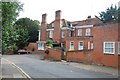
1
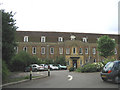
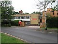
Brentwood Community Hospital, Brentwood, Essex
Image: © John Winfield
Taken: 1 Jul 2005
0.03 miles
3
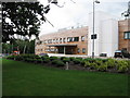
Brentwood Community Hospital, Crescent Drive, Brentwood, Pic A
Rebuilt* and opened on 11 August 2008. For more information on this Hospital see here: http://www.swessex.nhs.uk/content.asp?page_id=426
Another view is available here:
Image
*The original hospital on this site, dating from 1934, can be viewed in this 2005 image by John Winfield:
Image
Image: © Trevor Wright
Taken: 8 Jul 2009
0.20 miles
4
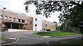
Brentwood Community Hospital, Crescent Drive, Brentwood, Pic B
Rebuilt* and opened on 11 August 2008. For more information on this Hospital see here: http://www.swessex.nhs.uk/content.asp?page_id=426
Another view is available here:
Image
*The original hospital on this site, dating from 1934, can be viewed in this 2005 image by John Winfield:
Image
Image: © Trevor Wright
Taken: 8 Jul 2009
0.20 miles
5
National Blood Service, Blood Donor Centre, Crescent Drive, Brentwood
For more information on how an ordinary person, like you or me, can do something amazing today, give blood, and improve or save a life see here: http://www.blood.co.uk/
Image: © Trevor Wright
Taken: 8 Jul 2009
0.22 miles
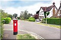
7
Postman's Trolley on the Corner
Corner of Cliveden Close and Worrin Road.
Image: © Des Blenkinsopp
Taken: 28 Jun 2024
0.24 miles
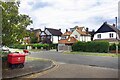
9
Shenfield Old Place
Once a large country house, Shenfield Old Place is now a large residential care home.
Image: © Trevor Harris
Taken: 4 Aug 2008
0.24 miles
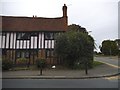
10
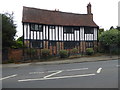
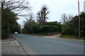
Old house in Shenfield
Shenfield has grown substantially since the original Shenfield station which opened in 1843 closed in March 1850 as passenger numbers were so low because there was little housing in the area. It was reopened on 1st January 1887 - see http://www.geograph.org.uk/photo/5395291 for more information about the station.
This old house on the corner of Shenfield Road with Worrin Road dates from the time when Shenfield was just a remote Essex village. It is just along the road from the 16th Century Coaching Inn Ye Olde Green Dragon - see http://www.geograph.org.uk/photo/5395427
Image: © Marathon
Taken: 17 May 2017
0.25 miles