IMAGES TAKEN NEAR TO
Priests Lane, BRENTWOOD, CM15 8BZ
Introduction
This page details the photographs taken nearby to Priests Lane, CM15 8BZ by members of the Geograph project.
The Geograph project started in 2005 with the aim of publishing, organising and preserving representative images for every square kilometre of Great Britain, Ireland and the Isle of Man.

There are currently over 7.5m images from over14,400 individuals and you can help contribute to the project by visiting https://www.geograph.org.uk
Image Map (Loading...)


Getting Data...Please wait
Leaflet Map data © OpenStreetMap
Images are licensed for reuse under creativecommons.org/licenses/by-sa/2.0
Notes
- Clicking on the map will re-center to the selected point.
- The higher the marker number, the further away the image location is from the centre of the postcode.
Image Listing (7 Images Found)
Images are licensed for reuse under creativecommons.org/licenses/by-sa/2.0
Image
Details
Distance
1
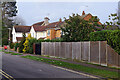
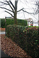
Glanthams Road, Shenfield
Glanthams Road leads off Priest's Lane in this leafy suburb. The area has been developed piecemeal since Edwardian times so there is a considerably variety of house styles.
Image: © Stephen McKay
Taken: 11 Jan 2023
0.06 miles
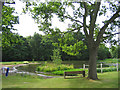
3
Brentwood Bank
Providing a challenge for 70013 Oliver Cromwell up the 1 in 103 incline.
Image: © Ashley Dace
Taken: 16 May 2009
0.22 miles
4
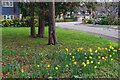
St Andrews Place, Brentwood
Notwithstanding a brief cold snap in December, the winter had been generally mild up to mid-January 2023. Even so, seeing these daffodils so early in the Brentwood suburbs was a surprise.
Image: © Stephen McKay
Taken: 11 Jan 2023
0.22 miles
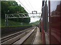
5
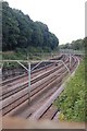
Railway Cutting, Brentwood
This view looks east from the Ingrave Road bridge.
Image: © Trevor Harris
Taken: 21 Aug 2008
0.23 miles
7
Public Footpath to Princes Way
This shows the Priest's Lane end of the path that provides a link across the railway.
Image: © Stephen McKay
Taken: 11 Jan 2023
0.24 miles