IMAGES TAKEN NEAR TO
Priests Lane, BRENTWOOD, CM15 8BU
Introduction
This page details the photographs taken nearby to Priests Lane, CM15 8BU by members of the Geograph project.
The Geograph project started in 2005 with the aim of publishing, organising and preserving representative images for every square kilometre of Great Britain, Ireland and the Isle of Man.

There are currently over 7.5m images from over14,400 individuals and you can help contribute to the project by visiting https://www.geograph.org.uk
Image Map
Images are licensed for reuse under creativecommons.org/licenses/by-sa/2.0
Notes
- Clicking on the map will re-center to the selected point.
- The higher the marker number, the further away the image location is from the centre of the postcode.
Image Listing (16 Images Found)
Images are licensed for reuse under creativecommons.org/licenses/by-sa/2.0
Image
Details
Distance
7
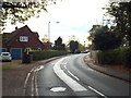
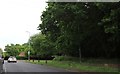
Middleton Hall Lane, Brentwood
A bend in the road on Middleton Hall Lane.
Image: © Malc McDonald
Taken: 28 Oct 2017
0.20 miles
8
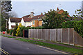
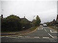
Glanthams Road, Shenfield
Glanthams Road leads off Priest's Lane in this leafy suburb. The area has been developed piecemeal since Edwardian times so there is a considerably variety of house styles.
Image: © Stephen McKay
Taken: 11 Jan 2023
0.21 miles
9
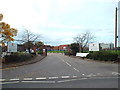
Entrance to Brentwood School
An entrance to the grounds of Brentwood School.
Image: © Malc McDonald
Taken: 28 Oct 2017
0.22 miles