IMAGES TAKEN NEAR TO
Wyatts Green Road, BRENTWOOD, CM15 0SR
Introduction
This page details the photographs taken nearby to Wyatts Green Road, CM15 0SR by members of the Geograph project.
The Geograph project started in 2005 with the aim of publishing, organising and preserving representative images for every square kilometre of Great Britain, Ireland and the Isle of Man.

There are currently over 7.5m images from over14,400 individuals and you can help contribute to the project by visiting https://www.geograph.org.uk
Image Map
Images are licensed for reuse under creativecommons.org/licenses/by-sa/2.0
Notes
- Clicking on the map will re-center to the selected point.
- The higher the marker number, the further away the image location is from the centre of the postcode.
Image Listing (5 Images Found)
Images are licensed for reuse under creativecommons.org/licenses/by-sa/2.0
Image
Details
Distance
1
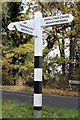
Direction Sign ? Signpost
Located on a grass triangle in the centre of the junction of Wyatts Green Road and Petits Lane in Blackmore, Hook End and Wyatts Green parish. 3 arms and pyramid finial.
Milestone Society National ID: EX_TQ6098
Image: © J Chisholm
Taken: 25 Nov 2019
0.05 miles
2
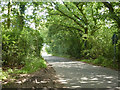
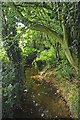
Pettits Lane
Nearing Wyatt's Green Road.
Image: © Robin Webster
Taken: 28 Jul 2012
0.06 miles
3
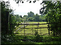
Horse lands
Off Pettits Lane, but not accessed this way.
Image: © Robin Webster
Taken: 28 Jul 2012
0.10 miles
4
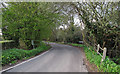
Small Bridge on Pettits Lane near Emblems Farm, Doddinghurst
Image: © Roger Jones
Taken: 13 Apr 2019
0.17 miles
5
The Wid From Emblands Bridge
The bridge is at the point where Pettits Lane becomes Mountnessing Lane.
Image: © Glyn Baker
Taken: 17 Aug 2012
0.17 miles