IMAGES TAKEN NEAR TO
Bakers Meadow, BRENTWOOD, CM15 0QL
Introduction
This page details the photographs taken nearby to Bakers Meadow, CM15 0QL by members of the Geograph project.
The Geograph project started in 2005 with the aim of publishing, organising and preserving representative images for every square kilometre of Great Britain, Ireland and the Isle of Man.

There are currently over 7.5m images from over14,400 individuals and you can help contribute to the project by visiting https://www.geograph.org.uk
Image Map
Images are licensed for reuse under creativecommons.org/licenses/by-sa/2.0
Notes
- Clicking on the map will re-center to the selected point.
- The higher the marker number, the further away the image location is from the centre of the postcode.
Image Listing (33 Images Found)
Images are licensed for reuse under creativecommons.org/licenses/by-sa/2.0
Image
Details
Distance
1
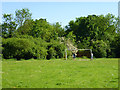
Recreation ground, Doddinghurst
There is another playing field beyond the substantial hedge.
Image: © Robin Webster
Taken: 26 May 2012
0.08 miles
2
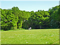
Recreation ground, Doddinghurst
Belts of trees surround this field.
Image: © Robin Webster
Taken: 26 May 2012
0.09 miles
3
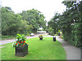
Doddinghurst Road, Doddinghurst, Essex
Looking north, with flower tubs at the corner of Brook Lane.
Image: © John Winfield
Taken: 6 Aug 2005
0.10 miles
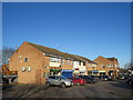
4
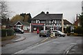
Shops in Doddinghurst
Taken from Doddinghurst Road, looking towards Church Lane, which is Doddinghurst's "main road".
Image: © Trevor Harris
Taken: 13 Nov 2008
0.13 miles
5
Shops in Doddinghurst
A small parade of shops in the Essex village of Doddinghurst.
This image was taken on a chilly but very sunny January afternoon. Trees were bare, the sun was low in the sky and shadows were long.
Image: © Malc McDonald
Taken: 18 Jan 2020
0.14 miles
6
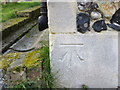
Ordnance Survey Cut Mark
This can be found on the wall of All Saints Church at Doddinghurst.
For more detail see : http://www.bench-marks.org.uk/bm68569
Image: © Peter Wood
Taken: 23 Feb 2015
0.16 miles
7
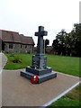
Modern War Memorial, All Saints' Church Doddinghurst
This memorial to WW1 and WW2 dead (including civilian deaths) was only constructed in 2014 (see inscription on the base).
Image: © Bikeboy
Taken: 13 Sep 2014
0.16 miles
8
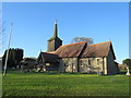
All Saints' Church, Doddinghurst
All Saints' Church in the village of Doddinghurst, in Essex. Parts of the building date from the 13th Century, although other parts are more recent. The church is a Grade I listed building. Further information about the church can be found on the British Listed Buildings website: https://britishlistedbuildings.co.uk/101197268-church-of-all-saints-doddinghurst
This image was taken on a chilly but very sunny January afternoon. Some of the trees were bare, the sun was low in the sky and shadows were long.
Image: © Malc McDonald
Taken: 18 Jan 2020
0.16 miles
9
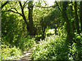
Public footpath to Dagwood Lane
Leaving recreation grounds through a tree belt.
Image: © Robin Webster
Taken: 26 May 2012
0.16 miles
10
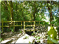
Bridge on public footpath to Dagwood Lane
Not a spectacular span.
Image: © Robin Webster
Taken: 26 May 2012
0.16 miles