IMAGES TAKEN NEAR TO
Wyatts Green Road, BRENTWOOD, CM15 0QB
Introduction
This page details the photographs taken nearby to Wyatts Green Road, CM15 0QB by members of the Geograph project.
The Geograph project started in 2005 with the aim of publishing, organising and preserving representative images for every square kilometre of Great Britain, Ireland and the Isle of Man.

There are currently over 7.5m images from over14,400 individuals and you can help contribute to the project by visiting https://www.geograph.org.uk
Image Map
Images are licensed for reuse under creativecommons.org/licenses/by-sa/2.0
Notes
- Clicking on the map will re-center to the selected point.
- The higher the marker number, the further away the image location is from the centre of the postcode.
Image Listing (3 Images Found)
Images are licensed for reuse under creativecommons.org/licenses/by-sa/2.0
Image
Details
Distance
1
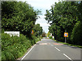
Wyatt's Green Road enters Wyatt's Green
Rampant stinging nettles obscure much of the sign, particularly some road safety exhortation.
Image: © Robin Webster
Taken: 28 Jul 2012
0.03 miles
2
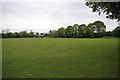
Wyatt's Green Rec
Not a soul getting exercise today on the Ted Marriage Playing Field
Image: © Glyn Baker
Taken: 8 May 2015
0.08 miles
3
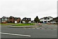
Wyatt's Green: Houses in Wyatt's Green Road
Image: © Michael Garlick
Taken: 17 Aug 2021
0.19 miles