IMAGES TAKEN NEAR TO
Second Avenue, BRENTWOOD, CM15 0HH
Introduction
This page details the photographs taken nearby to Second Avenue, CM15 0HH by members of the Geograph project.
The Geograph project started in 2005 with the aim of publishing, organising and preserving representative images for every square kilometre of Great Britain, Ireland and the Isle of Man.

There are currently over 7.5m images from over14,400 individuals and you can help contribute to the project by visiting https://www.geograph.org.uk
Image Map (Loading...)


Getting Data...Please wait
Leaflet Map data © OpenStreetMap
Images are licensed for reuse under creativecommons.org/licenses/by-sa/2.0
Notes
- Clicking on the map will re-center to the selected point.
- The higher the marker number, the further away the image location is from the centre of the postcode.
Image Listing (9 Images Found)
Images are licensed for reuse under creativecommons.org/licenses/by-sa/2.0
Image
Details
Distance
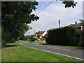
1
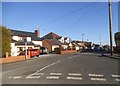
First Avenue, Hook End
The first house on the left has been built since 2009
Image: © David Howard
Taken: 25 Feb 2018
0.05 miles
2
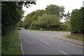
Dines Corner
Though it does not appear on the OS Landranger map, Dines Corner is the name shown on the white road sign here under the name Hook End Lane, which is seen on the right at its junction with Blackmore Road.
Image: © Trevor Harris
Taken: 9 Jul 2009
0.08 miles
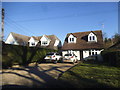
4
Cut silage field off Hook End Lane, Hook End
Image: © JThomas
Taken: 24 Aug 2022
0.17 miles
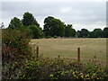
5
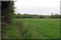
Footpath & Improved Grassland
This hay meadow is virtually a monoculture how it can be considered improved when compared to Image beats me.
Image: © Glyn Baker
Taken: 8 May 2015
0.17 miles
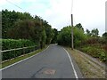
7
Hook End Lane, Hook End, Essex
Looking north towards Blackmore Road
Image: © John Winfield
Taken: 15 Aug 2005
0.20 miles
8
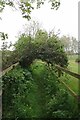
Time to Duck
I wonder how long this impediment to walkers has been here?
Image: © Glyn Baker
Taken: 8 May 2015
0.20 miles
9

Footpath to Blackmore Rd
This path begins at Image
Image: © Glyn Baker
Taken: 8 May 2015
0.23 miles