IMAGES TAKEN NEAR TO
Glovers Field, BRENTWOOD, CM15 0BD
Introduction
This page details the photographs taken nearby to Glovers Field, CM15 0BD by members of the Geograph project.
The Geograph project started in 2005 with the aim of publishing, organising and preserving representative images for every square kilometre of Great Britain, Ireland and the Isle of Man.

There are currently over 7.5m images from over14,400 individuals and you can help contribute to the project by visiting https://www.geograph.org.uk
Image Map (Loading...)


Getting Data...Please wait
Leaflet Map data © OpenStreetMap
Images are licensed for reuse under creativecommons.org/licenses/by-sa/2.0
Notes
- Clicking on the map will re-center to the selected point.
- The higher the marker number, the further away the image location is from the centre of the postcode.
Image Listing (9 Images Found)
Images are licensed for reuse under creativecommons.org/licenses/by-sa/2.0
Image
Details
Distance
1
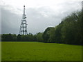
Radio mast
Although apparently a very rural scene, the mast towers over housing hidden beyond the distant hedge.
Image: © William Metcalfe
Taken: 12 May 2007
0.07 miles
2
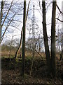
Doddinghurst Radio Mast
Viewed through the trees from the west.
Image: © Peter Wood
Taken: 23 Feb 2015
0.14 miles
3
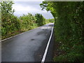
Country lane
School Road, Kelvedon Hatch, just before it turns right to join the A128.
Image: © William Metcalfe
Taken: 12 May 2007
0.18 miles
4
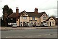
'The Shepherd Inn' on Blackmore Road
The inn dates back to the 15th century.
Image: © Robert Edwards
Taken: 19 Mar 2008
0.20 miles
5
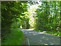
School Road, Kelvedon Hatch
Looking away from the village.
Image: © Robin Webster
Taken: 26 May 2012
0.20 miles
6
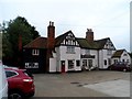
The Shepherd Inn
The building dates from around 1700 originally. See http://www.britishlistedbuildings.co.uk/en-373709-the-shepherd-public-house-kelvedon-hatch for entry in British Listed Buildings
Image: © Bikeboy
Taken: 13 Sep 2014
0.21 miles

8
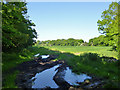
Field entrance off School Road
The shaded location has prevented these puddles from drying up much, in a fairly dry and dusty area after several very warm days.
Image: © Robin Webster
Taken: 26 May 2012
0.24 miles