IMAGES TAKEN NEAR TO
Micawber Way, CHELMSFORD, CM1 4UE
Introduction
This page details the photographs taken nearby to Micawber Way, CM1 4UE by members of the Geograph project.
The Geograph project started in 2005 with the aim of publishing, organising and preserving representative images for every square kilometre of Great Britain, Ireland and the Isle of Man.

There are currently over 7.5m images from over14,400 individuals and you can help contribute to the project by visiting https://www.geograph.org.uk
Image Map (Loading...)


Getting Data...Please wait
Leaflet Map data © OpenStreetMap
Images are licensed for reuse under creativecommons.org/licenses/by-sa/2.0
Notes
- Clicking on the map will re-center to the selected point.
- The higher the marker number, the further away the image location is from the centre of the postcode.
Image Listing (5 Images Found)
Images are licensed for reuse under creativecommons.org/licenses/by-sa/2.0
Image
Details
Distance
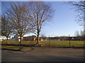
1

'Pocket Park', Copperfield Road, Chelmsford
The 1940 OS Map shows the whole of this square as being fields. Virtually the whole of it is now built on with a few 'pocket' parks between the houses.
Image: © John Winfield
Taken: 9 Feb 2006
0.05 miles
2

Morrisons on Copperfield Road, Chelmsford
Image: © David Howard
Taken: 25 Feb 2018
0.06 miles
4
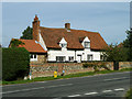
Chobbing's Farm
The house has quite a variety of window framing.
Image: © Robin Webster
Taken: 15 Sep 2011
0.19 miles
5
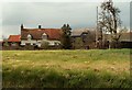
A view of Chobbing's Farm from Hollow Lane
Image: © Robert Edwards
Taken: 14 Apr 2008
0.20 miles