IMAGES TAKEN NEAR TO
Chignal Road, CHELMSFORD, CM1 4SY
Introduction
This page details the photographs taken nearby to Chignal Road, CM1 4SY by members of the Geograph project.
The Geograph project started in 2005 with the aim of publishing, organising and preserving representative images for every square kilometre of Great Britain, Ireland and the Isle of Man.

There are currently over 7.5m images from over14,400 individuals and you can help contribute to the project by visiting https://www.geograph.org.uk
Image Map (Loading...)


Getting Data...Please wait
Leaflet Map data © OpenStreetMap
Images are licensed for reuse under creativecommons.org/licenses/by-sa/2.0
Notes
- Clicking on the map will re-center to the selected point.
- The higher the marker number, the further away the image location is from the centre of the postcode.
Image Listing (7 Images Found)
Images are licensed for reuse under creativecommons.org/licenses/by-sa/2.0
Image
Details
Distance
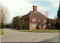
1
Woodhall Hill, Chignall Smealy
The outskirts of Chignall Smealy, a diffuse settlement whose 'centre' is little different to this part, in terms of population density.
Image: © Robin Webster
Taken: 15 Sep 2011
0.03 miles

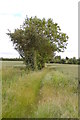
3
Footpath off Woodhall Hill
Heading north east.
Image: © Trevor Harris
Taken: 9 Jun 2015
0.09 miles

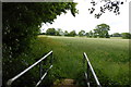
5
Footpath to Beaumont Otes
Starting here between Gray's Farm and Woodhall Farm.
Image: © Trevor Harris
Taken: 9 Jun 2015
0.16 miles
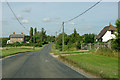
6
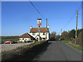
The Pig and Whistle Public House, Chignall Smealy
Looking north-west towards Chignall Smealy - the pub is situated about a mile outside the village.
Image: © John Winfield
Taken: 9 Feb 2006
0.17 miles