IMAGES TAKEN NEAR TO
Newarks Road, CHELMSFORD, CM1 4SA
Introduction
This page details the photographs taken nearby to Newarks Road, CM1 4SA by members of the Geograph project.
The Geograph project started in 2005 with the aim of publishing, organising and preserving representative images for every square kilometre of Great Britain, Ireland and the Isle of Man.

There are currently over 7.5m images from over14,400 individuals and you can help contribute to the project by visiting https://www.geograph.org.uk
Image Map (Loading...)


Getting Data...Please wait
Leaflet Map data © OpenStreetMap
Images are licensed for reuse under creativecommons.org/licenses/by-sa/2.0
Notes
- Clicking on the map will re-center to the selected point.
- The higher the marker number, the further away the image location is from the centre of the postcode.
Image Listing (3 Images Found)
Images are licensed for reuse under creativecommons.org/licenses/by-sa/2.0
Image
Details
Distance
1
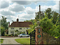
A peep in the gate at Newarks
Mapped as Great Newarks, the name plate leaves out the 'Great'.
Image: © Robin Webster
Taken: 15 Sep 2011
0.00 miles
2
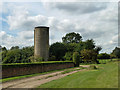
Old grain silo at Newarks
Standing just outside the neatly enclosed grounds of the house (formerly Great Newarks), this silo has been here since at least 1952. In those times and earlier there seems to have been farm buildings adjacent, just inside the house grounds. These have been demolished.
Image: © Robin Webster
Taken: 15 Sep 2011
0.04 miles
3
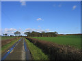
The road to Great Newarks
A 'dead-end' lane leading to a farm called Great Newarks, near Good Easter
Image: © John Winfield
Taken: 20 Jan 2006
0.18 miles