IMAGES TAKEN NEAR TO
High Easter, CHELMSFORD, CM1 4RD
Introduction
This page details the photographs taken nearby to CM1 4RD by members of the Geograph project.
The Geograph project started in 2005 with the aim of publishing, organising and preserving representative images for every square kilometre of Great Britain, Ireland and the Isle of Man.

There are currently over 7.5m images from over14,400 individuals and you can help contribute to the project by visiting https://www.geograph.org.uk
Image Map
Images are licensed for reuse under creativecommons.org/licenses/by-sa/2.0
Notes
- Clicking on the map will re-center to the selected point.
- The higher the marker number, the further away the image location is from the centre of the postcode.
Image Listing (3 Images Found)
Images are licensed for reuse under creativecommons.org/licenses/by-sa/2.0
Image
Details
Distance
1
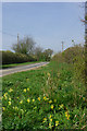
Cowslips by the lane
The lane being Slough Road just south of Peartree Cottage.
Image: © Robin Webster
Taken: 14 Apr 2007
0.05 miles
2
Part of Hill Farm
This is a view from Slough Road.
Image: © Robert Edwards
Taken: 25 Apr 2008
0.06 miles
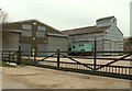
3

Hill Farm
Slough Road sweeps past the farm entrance to a junction whose fingerpost may just be seen over the hedge.
Image: © Robin Webster
Taken: 14 Apr 2007
0.06 miles