IMAGES TAKEN NEAR TO
The Street, CHELMSFORD, CM1 4QS
Introduction
This page details the photographs taken nearby to The Street, CM1 4QS by members of the Geograph project.
The Geograph project started in 2005 with the aim of publishing, organising and preserving representative images for every square kilometre of Great Britain, Ireland and the Isle of Man.

There are currently over 7.5m images from over14,400 individuals and you can help contribute to the project by visiting https://www.geograph.org.uk
Image Map (31 Images)


Leaflet Map data © OpenStreetMap
Images are licensed for reuse under creativecommons.org/licenses/by-sa/2.0
Notes
- Clicking on the map will re-center to the selected point.
- The higher the marker number, the further away the image location is from the centre of the postcode.
Image Listing (31 Images Found)
Images are licensed for reuse under creativecommons.org/licenses/by-sa/2.0
Image
Details
Distance
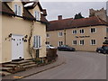
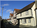
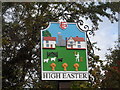
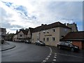
1
High Easter village
This picture shows The Street as viewed from School Lane. The village sign is on the left of the picture.
Image: © Robert Edwards
Taken: 25 Apr 2008
0.05 miles
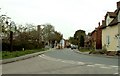
2
High Easter, Essex
This photo shows the approach to St. Mary the Virgin Church which dates back to the Norman period.
Image: © Robert Edwards
Taken: 7 Sep 2005
0.09 miles
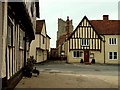
3

Cock & Bell House, High Easter
A grade II* listed building that was a public house until the last quarter of the last century
Image: © Phil Gaskin
Taken: 4 May 2009
0.09 miles
4
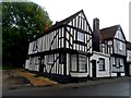
The former Cock and Bell pub, High Easter
The building dates from around around 1400. A cross wing was added in C16. See http://www.britishlistedbuildings.co.uk/en-121364-cock-and-bell-high-easter-essex for entry in British Listed Buildings
Image: © Bikeboy
Taken: 11 Oct 2014
0.09 miles
5
15th century cottages, High Easter
The cottage on the right of the picture has the date 1420 marked on the wall.
Image: © John Winfield
Taken: 20 Jan 2006
0.09 miles
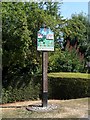
8
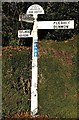
Direction Sign ? Signpost
Located on the northeast side of the T junction of School Lane and The Street in High Easter parish. 3 arms and half-moon finial.
Milestone Society National ID: EX_TL6214
Image: © M Bardell
Taken: 4 Dec 2019
0.09 miles
9
The Punch Bowl, High Easter
C16 house now used as a restaurant. See http://www.britishlistedbuildings.co.uk/en-121379-the-punch-bowl-high-easter-essex for entry in British Listed Buildings
Image: © Bikeboy
Taken: 11 Oct 2014
0.10 miles