IMAGES TAKEN NEAR TO
The Street, CHELMSFORD, CM1 4QR
Introduction
This page details the photographs taken nearby to The Street, CM1 4QR by members of the Geograph project.
The Geograph project started in 2005 with the aim of publishing, organising and preserving representative images for every square kilometre of Great Britain, Ireland and the Isle of Man.

There are currently over 7.5m images from over14,400 individuals and you can help contribute to the project by visiting https://www.geograph.org.uk
Image Map (Loading...)


Getting Data...Please wait
Leaflet Map data © OpenStreetMap
Images are licensed for reuse under creativecommons.org/licenses/by-sa/2.0
Notes
- Clicking on the map will re-center to the selected point.
- The higher the marker number, the further away the image location is from the centre of the postcode.
Image Listing (7 Images Found)
Images are licensed for reuse under creativecommons.org/licenses/by-sa/2.0
Image
Details
Distance
1
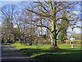
Village Green, High Easter, Essex
One of a number of villages in this area with the name 'Easter'.
Image: © John Winfield
Taken: 20 Jan 2006
0.06 miles
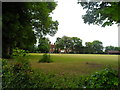
3
High Easter village hall
By a field used for football. The large car park appears to be open to the general public.
Image: © Robin Webster
Taken: 15 Sep 2011
0.11 miles
4
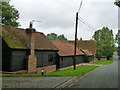
Converted barns, High Easter
These are part of Parsonage Farm, which seems to be residential only now.
Image: © Robin Webster
Taken: 8 Sep 2011
0.14 miles
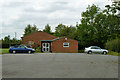
5
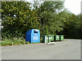
Recycling bins, High Easter
In the village hall car park.
Image: © Robin Webster
Taken: 15 Sep 2011
0.16 miles
6
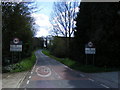
High Easter village signs
Taken at start of Village on High Easter Road
Image: © PAUL FARMER
Taken: 11 Apr 2010
0.21 miles
7
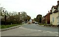
High Easter village
This picture shows The Street as viewed from School Lane. The village sign is on the left of the picture.
Image: © Robert Edwards
Taken: 25 Apr 2008
0.23 miles