IMAGES TAKEN NEAR TO
Skreens Park Road, CHELMSFORD, CM1 4NN
Introduction
This page details the photographs taken nearby to Skreens Park Road, CM1 4NN by members of the Geograph project.
The Geograph project started in 2005 with the aim of publishing, organising and preserving representative images for every square kilometre of Great Britain, Ireland and the Isle of Man.

There are currently over 7.5m images from over14,400 individuals and you can help contribute to the project by visiting https://www.geograph.org.uk
Image Map
Images are licensed for reuse under creativecommons.org/licenses/by-sa/2.0
Notes
- Clicking on the map will re-center to the selected point.
- The higher the marker number, the further away the image location is from the centre of the postcode.
Image Listing (3 Images Found)
Images are licensed for reuse under creativecommons.org/licenses/by-sa/2.0
Image
Details
Distance
1
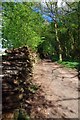
Wood Pile Near Skreens Park
Quite a few cord in this pile
Image: © Glyn Baker
Taken: 18 Apr 2017
0.08 miles
2
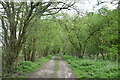
Track to Hawthorn Cottage
The track here - also a footpath - runs along the edge of the woodland to the north of Skreens Park.
Image: © Trevor Harris
Taken: 15 Apr 2022
0.12 miles
3
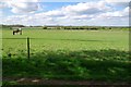
Paddocks Near Skreens Park
I am not sure if horse riding is one of the activities provided at the adventure centre https://www.skreenspark.org.uk/ or if thhese paddocks are part of another equestrian enterprise.
Image: © Glyn Baker
Taken: 18 Apr 2017
0.14 miles