IMAGES TAKEN NEAR TO
Hoe Street, CHELMSFORD, CM1 4LX
Introduction
This page details the photographs taken nearby to Hoe Street, CM1 4LX by members of the Geograph project.
The Geograph project started in 2005 with the aim of publishing, organising and preserving representative images for every square kilometre of Great Britain, Ireland and the Isle of Man.

There are currently over 7.5m images from over14,400 individuals and you can help contribute to the project by visiting https://www.geograph.org.uk
Image Map
Images are licensed for reuse under creativecommons.org/licenses/by-sa/2.0
Notes
- Clicking on the map will re-center to the selected point.
- The higher the marker number, the further away the image location is from the centre of the postcode.
Image Listing (6 Images Found)
Images are licensed for reuse under creativecommons.org/licenses/by-sa/2.0
Image
Details
Distance
1
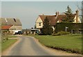
Looking along Hoestreet to Hoestreet Farm
Image: © Robert Edwards
Taken: 22 Apr 2008
0.03 miles
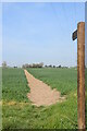
2
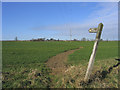
Footpath to Roxwell
Footpath runs north-west from Hoestreet to Roxwell
Image: © John Winfield
Taken: 9 Feb 2006
0.04 miles
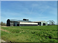
3
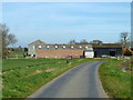
Barns, Hoe Street Farm
Looking from Gravelly Lane. This becomes Hoe Street a little way ahead, the side-by-side signs are on the left verge.
Image: © Robin Webster
Taken: 25 Mar 2012
0.07 miles
4
Hoestreet near Roxwell
Small scattering of house halfway between Roxwell and Newney Green
Image: © John Winfield
Taken: 9 Feb 2006
0.09 miles
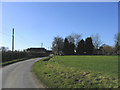
5
Barns, Hoe Street
These probably belong to Little Thatchers Farm whose principal buildings are across the road.
Image: © Robin Webster
Taken: 25 Mar 2012
0.12 miles
6
Footpath at Hoestreet
The path heads north west towards Roxwell.
Image: © Trevor Harris
Taken: 15 Apr 2022
0.13 miles