IMAGES TAKEN NEAR TO
The Street, CHELMSFORD, CM1 4LB
Introduction
This page details the photographs taken nearby to The Street, CM1 4LB by members of the Geograph project.
The Geograph project started in 2005 with the aim of publishing, organising and preserving representative images for every square kilometre of Great Britain, Ireland and the Isle of Man.

There are currently over 7.5m images from over14,400 individuals and you can help contribute to the project by visiting https://www.geograph.org.uk
Image Map
Images are licensed for reuse under creativecommons.org/licenses/by-sa/2.0
Notes
- Clicking on the map will re-center to the selected point.
- The higher the marker number, the further away the image location is from the centre of the postcode.
Image Listing (42 Images Found)
Images are licensed for reuse under creativecommons.org/licenses/by-sa/2.0
Image
Details
Distance
1
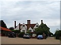
Dukes House, Roxwell
A manor house on this site is recorded in The Domesday Book. This house was built in C16 but added to in 1666. There is a wooden pannel over the door inscribed "1666 T.A.C" (T.A.C.-Thomas Arthur Crush for whom the house was modified). See http://www.britishlistedbuildings.co.uk/en-426697-dukes-house-roxwell-essex#.VctJBvlViko for Entry in British Listed Buildings. There is an unsubstantiated story that builders on the roof in 1666 could see the Great Fire of London.
Image: © Bikeboy
Taken: 11 Aug 2015
0.00 miles
3
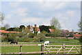
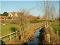
View towards Dukes Manor, Roxwell
Looking across Roxwell Brook from the western end of The Street.
Image: © Trevor Harris
Taken: 15 Apr 2022
0.04 miles
4
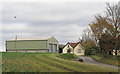
Junction, Boyton Cross Lane and Skreens Park Road, Roxwell
Image: © Robin Webster
Taken: 25 Mar 2012
0.07 miles
5
Dukes Farm and Roxwell Brook
Dukes dates from the 16th century. Roxwell Brook joins the River Can to the north of Writtle.
Image: © Paul Franks
Taken: 14 Feb 2023
0.07 miles
7
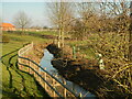
Roxwell Brook
Looking upstream in the direction of Lightfoots.
Image: © Paul Franks
Taken: 14 Feb 2023
0.13 miles
8
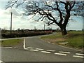
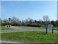
A road junction on Elms Road
The farm in the distance is called Lightfoots.
Image: © Robert Edwards
Taken: 12 Mar 2008
0.15 miles
9
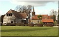
St. Michael & All Angels; the parish church of Roxwell
The nave and chancel date from the 14th century though they are restored beyond recognition. The north aisle was added in 1854 and the belfry in 1891. This view from the south shows a very attractive converted barn.
Image: © Robert Edwards
Taken: 4 Mar 2008
0.16 miles
10
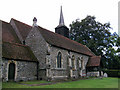
St Michael and All Angels Church Roxwell Essex
Image: © Peter Stack
Taken: 3 Aug 2008
0.16 miles