IMAGES TAKEN NEAR TO
Hollow Lane, CHELMSFORD, CM1 4GE
Introduction
This page details the photographs taken nearby to Hollow Lane, CM1 4GE by members of the Geograph project.
The Geograph project started in 2005 with the aim of publishing, organising and preserving representative images for every square kilometre of Great Britain, Ireland and the Isle of Man.

There are currently over 7.5m images from over14,400 individuals and you can help contribute to the project by visiting https://www.geograph.org.uk
Image Map
Images are licensed for reuse under creativecommons.org/licenses/by-sa/2.0
Notes
- Clicking on the map will re-center to the selected point.
- The higher the marker number, the further away the image location is from the centre of the postcode.
Image Listing (6 Images Found)
Images are licensed for reuse under creativecommons.org/licenses/by-sa/2.0
Image
Details
Distance
1
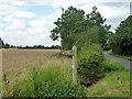
Footpath leaving Hollow Lane
The path takes a short cut over the lane route to Beaumont Oates.
Image: © Robin Webster
Taken: 28 Jul 2012
0.15 miles
2

'Pocket Park', Copperfield Road, Chelmsford
The 1940 OS Map shows the whole of this square as being fields. Virtually the whole of it is now built on with a few 'pocket' parks between the houses.
Image: © John Winfield
Taken: 9 Feb 2006
0.18 miles
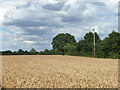
3

Tractor tracks in wheat
A field west of Hollow Lane.
Image: © Robin Webster
Taken: 28 Jul 2012
0.18 miles
4
Wheat field west of Hollow Lane
Hollow Lane is behind the hedge on the right.
Image: © Robin Webster
Taken: 28 Jul 2012
0.18 miles
5
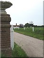
Priors
Driveway to Priors, a large period house set in extensive grounds
Image: © John Myers
Taken: 14 May 2008
0.20 miles
6
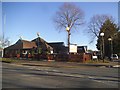
Morrisons on Copperfield Road, Chelmsford
Image: © David Howard
Taken: 25 Feb 2018
0.25 miles